IMAGES TAKEN NEAR TO
Masters Drive, LONDON, SE16 3DT
Introduction
This page details the photographs taken nearby to Masters Drive, SE16 3DT by members of the Geograph project.
The Geograph project started in 2005 with the aim of publishing, organising and preserving representative images for every square kilometre of Great Britain, Ireland and the Isle of Man.

There are currently over 7.5m images from over14,400 individuals and you can help contribute to the project by visiting https://www.geograph.org.uk
Image Map
Images are licensed for reuse under creativecommons.org/licenses/by-sa/2.0
Notes
- Clicking on the map will re-center to the selected point.
- The higher the marker number, the further away the image location is from the centre of the postcode.
Image Listing (77 Images Found)
Images are licensed for reuse under creativecommons.org/licenses/by-sa/2.0
Image
Details
Distance
1
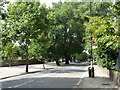
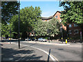
Rotherhithe New Road
The bus stop partly hidden by the tree is served by route P12 towards Peckham. The stop is called Sheppard Drive.
Image: © Robin Webster
Taken: 23 Jul 2011
0.03 miles
2
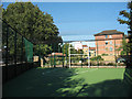
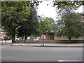
Basketball practice area, Masters Drive
The photo is from the vertex of a triangular area of all-weather surface, fenced all round and with netting above. There is just one hoop at the 'broad' end of the triangle, so it can only be used for practice, not a match.
Image: © Stephen Craven
Taken: 19 Aug 2009
0.04 miles
3
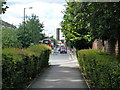
Caitlin Street
Looking down a path that cuts the corner with Rotherhithe New Road. This was the old route of Caitlin Street before the acute junction was made into a safer right-angled one.
Image: © Robin Webster
Taken: 23 Jul 2011
0.06 miles
4
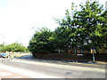
Catlin Street cycle crossing
In April 2013, improvements were made to London Cycle Network route 2 in the South Bermondsey area, including moving the crossing point of Catlin Street about ten metres further west to opposite the entrance to Stevenson Close. From a cyclist’s point of view, this had the disadvantage of taking one away from where there was a clear view of traffic turning into Catlin Street, thereby adding some risk to what had been a very safe crossing point.
Image: © Stephen Craven
Taken: 17 Jul 2013
0.09 miles
5
Cycle path alongside Rotherhithe New Road
This particularly wide pavement has been put to good use as a two-way segregated cycle track. Compare with the same road further west Image
Image: © Stephen Craven
Taken: 18 Jul 2009
0.09 miles
6
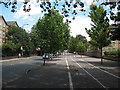
Rotherhithe New Road, SE16
Looking north east.
Image: © Philip Talmage
Taken: 18 Nov 2005
0.09 miles
7
Ryder Drive, South Bermondsey
One of two parallel roads forming the basis of the pattern of housing on this estate, the other being Masters Drive. Golf enthusiasts will not be surprised to learn that the individual closes off these roads are named after courses, e.g. Sunningdale Close.
The bicycle symbols in the foreground indicate that the road is part of London Cycle Network - route 2.
Image: © Stephen Craven
Taken: 19 Aug 2009
0.09 miles
8
Empress of India (site of). 285 Rotherhithe New Road, London SE16
Just down from Credon Road, first recorded in 1883 and closed 1967. From 1864 to 1882 it was called the "Old Galley Wall". It was a three-storeyed building that in 1960 was quite colourful.
Image: © Chris Lordan
Taken: 19 Oct 2009
0.11 miles
9
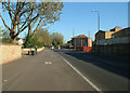
Rotherhithe New Road
Looking west from the junction with Ilderton Road, after remodelling in 2010.
Image: © Stephen Craven
Taken: 21 May 2011
0.11 miles
10
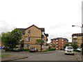
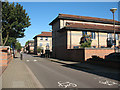
Stubbs Drive, South Bermondsey
The eastern end of a large housing estate.
Image: © Stephen Craven
Taken: 9 May 2013
0.12 miles