IMAGES TAKEN NEAR TO
Verney Road, LONDON, SE16 3DL
Introduction
This page details the photographs taken nearby to Verney Road, SE16 3DL by members of the Geograph project.
The Geograph project started in 2005 with the aim of publishing, organising and preserving representative images for every square kilometre of Great Britain, Ireland and the Isle of Man.

There are currently over 7.5m images from over14,400 individuals and you can help contribute to the project by visiting https://www.geograph.org.uk
Image Map
Images are licensed for reuse under creativecommons.org/licenses/by-sa/2.0
Notes
- Clicking on the map will re-center to the selected point.
- The higher the marker number, the further away the image location is from the centre of the postcode.
Image Listing (83 Images Found)
Images are licensed for reuse under creativecommons.org/licenses/by-sa/2.0
Image
Details
Distance
1
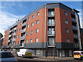
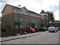
Batwa House, Varcoe Road, South Bermondsey
A modern apartment block.
Image: © Stephen Craven
Taken: 10 Jul 2015
0.04 miles
2
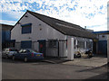
Varcoe Service Station, South Bermondsey
A vehicle maintenance business on Varcoe Road, an area which is now otherwise mainly residential.
Image: © Stephen Craven
Taken: 10 Jul 2015
0.04 miles
3
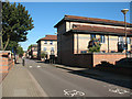
Ryder Drive, South Bermondsey
One of two parallel roads forming the basis of the pattern of housing on this estate, the other being Masters Drive. Golf enthusiasts will not be surprised to learn that the individual closes off these roads are named after courses, e.g. Sunningdale Close.
The bicycle symbols in the foreground indicate that the road is part of London Cycle Network - route 2.
Image: © Stephen Craven
Taken: 19 Aug 2009
0.05 miles
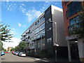
4
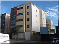
Buildings with unusual cladding, South Bermondsey
Modern apartment blocks on Varcoe Road, with distinctive cladding and curved roofs.
Image: © Stephen Craven
Taken: 10 Jul 2015
0.06 miles
5
Site of St Bartholomew's church
This is a block of social housing on the south side of Barkworth Road, South Bermondsey. It was built by the Southwark and London Diocesan Housing Association on the site of St Bartholomew's church which occupied the site from 1887 to 1994. http://www.southwark.anglican.org/downloads/lostchurches/CAM06.pdf The church heritage is reflected in the small pinnacled tower on the corner of the new block.
Image: © Stephen Craven
Taken: 18 Jul 2009
0.06 miles
6
Crown Place, Varcoe Road, South Bermondsey
A modern apartment block.
Image: © Stephen Craven
Taken: 10 Jul 2015
0.07 miles
7
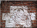
Plaque on former vicarage, Barkworth Road, South Bermondsey
For context, see Image
Image: © Stephen Craven
Taken: 14 Apr 2015
0.07 miles
8
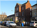
Former vicarage, Barkworth Road, South Bermondsey
The vicarage was associated with the adjacent St Bartholomew's church, which has now been replaced with housing Image
Image: © Stephen Craven
Taken: 14 Apr 2015
0.07 miles
9
Traffic barrier, Varcoe Road, South Bermondsey
Barriers like this are needed on most of the residential streets in this area as otherwise they become rat runs for drivers trying to escape the congestion on the Old Kent Road. Space is left at one end for cyclist permeability.
Image: © Stephen Craven
Taken: 10 Jul 2015
0.08 miles
10
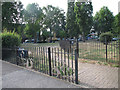
Bramcote Park, South Bermondsey
The entrance off Varcoe Road. The "park" is in fact just a pair of small areas each about 50x50m either side of Verney Road.
Image: © Stephen Craven
Taken: 10 Jul 2015
0.12 miles