IMAGES TAKEN NEAR TO
Barkworth Road, LONDON, SE16 3BZ
Introduction
This page details the photographs taken nearby to Barkworth Road, SE16 3BZ by members of the Geograph project.
The Geograph project started in 2005 with the aim of publishing, organising and preserving representative images for every square kilometre of Great Britain, Ireland and the Isle of Man.

There are currently over 7.5m images from over14,400 individuals and you can help contribute to the project by visiting https://www.geograph.org.uk
Image Map
Images are licensed for reuse under creativecommons.org/licenses/by-sa/2.0
Notes
- Clicking on the map will re-center to the selected point.
- The higher the marker number, the further away the image location is from the centre of the postcode.
Image Listing (142 Images Found)
Images are licensed for reuse under creativecommons.org/licenses/by-sa/2.0
Image
Details
Distance
1
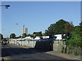
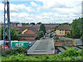
Ilderton Road, SE16
Ilderton Road in South Bermondsey. Just visible above the vans in the yard is a Southern train calling at South Bermondsey station.
Image: © Malc McDonald
Taken: 10 Oct 2010
0.03 miles
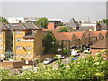
2
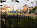
Bramcote Grove Playground, Rotherhithe, London SE16
At the junction with Barkworth and Verney Roads - when the area was revamped it was planned to build dwellings on the playground until it was discovered that the ground was donated by a wealthy benefactor for locals to use "in perpetuity" as a park (in 1914 dwellings were on the site). Believe the benefactor was from Chislehurst in Kent as people from that area donated large amounts of cash for this particular part of Rotherhithe in the late 1800s.
Image: © Chris Lordan
Taken: 23 Sep 2009
0.05 miles
3
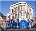
Bramcote pub. 68, Bramcote Grove, Rotherhithe, London, SE16
At the junction with Barkworth Road and as it has 1886 on side, can only assume that was when it was built. Known for many years as The Bramcote Arms but now known just as the Bramcote, although the owners seem to be backing it both ways.
Image: © Chris Lordan
Taken: 12 Oct 2009
0.05 miles
4
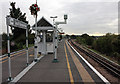
South Bermonsdey Station
Looking down the line towards Peckham. Weekday services operate to London Bridge, Victoria, West Croydon and Beckenham Junction. On Sundays the service is reduced with Victoria, London Bridge and East Croydon being the destinations.
Image: © Martin Addison
Taken: 22 Oct 2010
0.06 miles
5
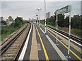
South Bermondsey railway station, Greater London
Opened in 1928 by the Southern Railway on the line from London Bridge to Streatham via Peckham Rye, this station replaced an earlier one slightly further north.
View north towards London Bridge.
Image: © Nigel Thompson
Taken: 18 Sep 2016
0.07 miles
6
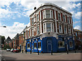
The Bramcote Arms
On the corner of Bramcote Grove and Barkworth Road, a typical 19th century London "local" pub, serving the streets around it. Unlike many others, and unlike the local church Image, this one survived redevelopment of the area and is still open.
Image: © Stephen Craven
Taken: 18 Jul 2009
0.07 miles
7
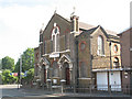
Christ Apostolic Church, Deptford
The church is on the corner of Ilderton Road and Zampa Road.
Image: © Stephen Craven
Taken: 22 May 2009
0.07 miles
8
View west from South Bermondsey station
Looking down Delaford Road.
Image: © Robin Webster
Taken: 23 Jul 2011
0.07 miles
9
Ilderton Road: housing, from South Bermondsey station
Image: © Christopher Hilton
Taken: 2 Jun 2011
0.08 miles
10
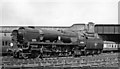
Rebuilt Bulleid 'West Country' 4-6-2 at North Kent West Junction, South Bermondsey
Coming off the Bricklayer's Arms branch is rebuilt Bulleid light Pacific No. 34004 'Yeovil' (built 7/45 as No. 21C104 'Yeovil', renumbered 5/48, rebuilt 2/58, withdrawn 10/66). The bridge behind carries the South London line.
Image: © Ben Brooksbank
Taken: 9 Jul 1958
0.08 miles