IMAGES TAKEN NEAR TO
Silwood Street, LONDON, SE16 2SU
Introduction
This page details the photographs taken nearby to Silwood Street, SE16 2SU by members of the Geograph project.
The Geograph project started in 2005 with the aim of publishing, organising and preserving representative images for every square kilometre of Great Britain, Ireland and the Isle of Man.

There are currently over 7.5m images from over14,400 individuals and you can help contribute to the project by visiting https://www.geograph.org.uk
Image Map
Images are licensed for reuse under creativecommons.org/licenses/by-sa/2.0
Notes
- Clicking on the map will re-center to the selected point.
- The higher the marker number, the further away the image location is from the centre of the postcode.
Image Listing (225 Images Found)
Images are licensed for reuse under creativecommons.org/licenses/by-sa/2.0
Image
Details
Distance
1
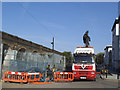
Pipe delivery on Silwood Street
The pipes being offloaded here were probably hot water pipes for the district heating system, powered from the nearby incineration plant Image and which was being expanded in 2014 to serve new developments on the Silwood Estate.
Image: © Stephen Craven
Taken: 16 Apr 2014
0.01 miles
2
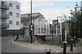
Silwood Street games area, Deptford
The path beside the Overground line is behind the camera.
Photo number 7881433.
Image: © Robin Stott
Taken: 29 Aug 2024
0.02 miles
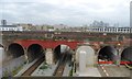
4
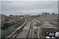
Bridges over the Overground
An overground service to Clapham Junction passes under the middle one of three parallel railway bridges north of the Surrey Canal Road. They carry the southeastern main lines.
Photo number 7881377.
Image: © Robin Stott
Taken: 29 Aug 2024
0.02 miles
6
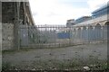
Silwood Street, Deptford
Development or redevelopment appears to be taking place alongside or as a result of the new railway bridge in Image
Photo number 7883903.
Image: © Robin Stott
Taken: 29 Aug 2024
0.03 miles
7
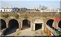
Bridges over the Overground
This is the view northwest after passing under the railway bridge in Image It can't be reconciled with current maps, which should show the northernmost of three parallel bridges carrying mainlines from London Bridge. In other photos of the bridge on the right it appears new. The conclusion must be that it is indeed new, replacing an older bridge but on a more northerly line.
Photo number 7881411.
Image: © Robin Stott
Taken: 29 Aug 2024
0.04 miles
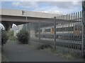
9
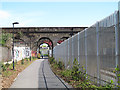
Cycle path alongside the Overground
This path threads its way underneath three railway viaducts, of which two are seen in this view. The security fence on the right separates the cycleway from the London Overground railway line which reopened in 2012.
Image: © Stephen Craven
Taken: 2 May 2013
0.05 miles
10
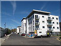
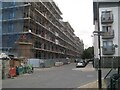
New housing on Silwood Street
A housing association development adjacent to the London-Greenwich railway line, as seen in a view during construction Image They replaced older blocks of housing of a similar height Image
Image: © Stephen Craven
Taken: 2 May 2013
0.05 miles