IMAGES TAKEN NEAR TO
St. Helena Road, LONDON, SE16 2QY
Introduction
This page details the photographs taken nearby to St. Helena Road, SE16 2QY by members of the Geograph project.
The Geograph project started in 2005 with the aim of publishing, organising and preserving representative images for every square kilometre of Great Britain, Ireland and the Isle of Man.

There are currently over 7.5m images from over14,400 individuals and you can help contribute to the project by visiting https://www.geograph.org.uk
Image Map
Images are licensed for reuse under creativecommons.org/licenses/by-sa/2.0
Notes
- Clicking on the map will re-center to the selected point.
- The higher the marker number, the further away the image location is from the centre of the postcode.
Image Listing (195 Images Found)
Images are licensed for reuse under creativecommons.org/licenses/by-sa/2.0
Image
Details
Distance
1
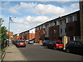
New housing on Eugenia Road
The low-rise housing on the south side of the road was built c. 2006.
Image: © Stephen Craven
Taken: 20 Aug 2009
0.02 miles
3
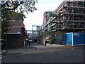
Sir Garnet Wolseley pub (site of) 6, Warndon Street, Rotherhithe, London, SE16
The pub would have stood on the entrance where the estate road has been constructed, at the then junction with Silverlock Street. The pub opened in 1878 and closed in 1971. Building on the left is McIntosh House and that on the right is Westlake House. Westlake Road ran off Silverlock Street and both terminated in Silwood Street.
Image: © Chris Lordan
Taken: 4 Nov 2009
0.04 miles
4
St Katharine with St Bartholomew, Eugenia Road - East end
Image: © John Salmon
Taken: 17 Feb 2011
0.05 miles
5
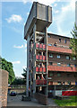
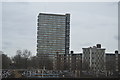
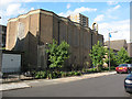
Detail of Silwood Estate, Millender Street
Prodigious service tower on the end of a deck access block.
Image: © Stephen Richards
Taken: 26 May 2013
0.05 miles
6
St Katharine with St Bartholomew, Eugenia Road
Image: © John Salmon
Taken: 17 Feb 2011
0.05 miles
7
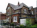
St Katharine's Vicarage Eugenia Road
Built as the same time as the 1905 church that was destroyed in 1940 during WWII. The present church is the third.
Image: © Chris Lordan
Taken: 6 Mar 2008
0.06 miles
8
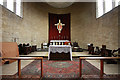
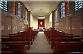
St Katharine with St Bartholomew, Eugenia Road - Sanctuary
Image: © John Salmon
Taken: 17 Feb 2011
0.06 miles
9
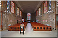
St Katharine with St Bartholomew, Eugenia Road - West end
Image: © John Salmon
Taken: 17 Feb 2011
0.06 miles
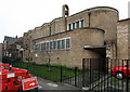
10
St Katharine's church, South Bermondsey
This Anglican parish church was built in 1960 to the designs of Covell, Matthews and Partners, on the site of an earlier 19th century church that had been badly damaged by wartime bombing. It is notable for its copper roof and 'zig-zag' walls.
Image: © Stephen Craven
Taken: 20 Aug 2009
0.06 miles