IMAGES TAKEN NEAR TO
Regeneration Road, LONDON, SE16 2NY
Introduction
This page details the photographs taken nearby to Regeneration Road, SE16 2NY by members of the Geograph project.
The Geograph project started in 2005 with the aim of publishing, organising and preserving representative images for every square kilometre of Great Britain, Ireland and the Isle of Man.

There are currently over 7.5m images from over14,400 individuals and you can help contribute to the project by visiting https://www.geograph.org.uk
Image Map
Images are licensed for reuse under creativecommons.org/licenses/by-sa/2.0
Notes
- Clicking on the map will re-center to the selected point.
- The higher the marker number, the further away the image location is from the centre of the postcode.
Image Listing (187 Images Found)
Images are licensed for reuse under creativecommons.org/licenses/by-sa/2.0
Image
Details
Distance
1
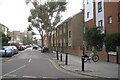
Reculver Road, Deptford
To the west of the Silwood Triangle (Overground-land) is a larger residential triangle bounded by railway lines to its east and south: the Silwood Estate, which in places appears to have been redeveloped.
Photo number 7885429.
Image: © Robin Stott
Taken: 29 Aug 2024
0.03 miles
2
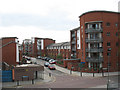
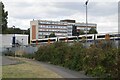
Island Road, Rotherhithe
A recent building development to the west of Oldfield Grove, viewed from the railway footbridge.
Image: © Stephen Craven
Taken: 27 Apr 2010
0.03 miles
3
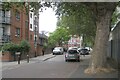
Oldfield Grove, Deptford
Just showing on the right is the Network Rail facility first seen in Image
Photo number 7885393.
Image: © Robin Stott
Taken: 29 Aug 2024
0.04 miles
4
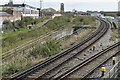
Railway junction south of Surrey Quays
A complex area of tracks, where the former East London Line has been integrated into the Overground network.
Image: © David Martin
Taken: 10 Apr 2022
0.05 miles
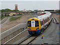
5
Train by Somerfield Street, Deptford
An Overground train from the New Cross Gate direction and at a higher level than Image, slows on the approach to Surrey Quays station. The building on the left turns out to be a Network Rail outpost, occupied by a contractor; it is an East London Line Infrastructure Maintenance Facility. This may be the site reached from Sainsbury's delivery compound at New Cross Gate Image
Image: © Robin Stott
Taken: 29 Aug 2024
0.06 miles
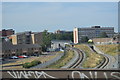
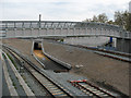
6
Overground lines south of Surrey Quays
The train seen in Image is about to go out of sight, left, heading probably for New Cross Gate. The line to Clapham Junction, via Peckham, is concealed in a cutting, centre. The line from New Cross and New Cross Gate bridges it and is then joined by the line from Peckham that has climbed up to it, right. The view is from the ramp up to the footbridge that connects Oldfield Grove and Trundley's Terrace.
Photo number 7885455.
Image: © Robin Stott
Taken: 29 Aug 2024
0.06 miles
7
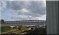
Deptford Road Junction: first day of reopening
Unit 378152 on a journey from New Cross Gate to Shoreditch takes the new single track flyover crossing the route of the projected Peckham link line. The front of the train bears a poster with the London Overground logo and "first passenger train - April 2010". The lack of a precise date on the poster reflects the fact that the exact opening date was only known a few days in advance.
Image: © Stephen Craven
Taken: 27 Apr 2010
0.07 miles
9
Footbridge at Deptford Road Junction
The footbridge over the former East London Line railway, linking Trundleys Road to Oldfield Grove, was rebuilt with access ramps each side as part of the redevelopment of the junction for the London Overground project.
Image: © Stephen Craven
Taken: 27 Apr 2010
0.07 miles
10
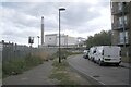
The walk by the Overground
Between the Overground behind the fence and Somerfield Street a footpath runs through to the Surrey Canal Road. In the background is the incinerator at Landmann Way.
Photo number 7885400.
Image: © Robin Stott
Taken: 29 Aug 2024
0.07 miles