IMAGES TAKEN NEAR TO
Burnham Close, LONDON, SE1 5RL
Introduction
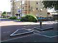
This page details the photographs taken nearby to Burnham Close, SE1 5RL by members of the Geograph project.
The Geograph project started in 2005 with the aim of publishing, organising and preserving representative images for every square kilometre of Great Britain, Ireland and the Isle of Man.

There are currently over 7.5m images from over14,400 individuals and you can help contribute to the project by visiting https://www.geograph.org.uk
Image Map
Images are licensed for reuse under creativecommons.org/licenses/by-sa/2.0
Notes
- Clicking on the map will re-center to the selected point.
- The higher the marker number, the further away the image location is from the centre of the postcode.
Image Listing (114 Images Found)
Images are licensed for reuse under creativecommons.org/licenses/by-sa/2.0
Image
Details
Distance
1
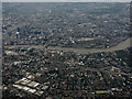
Bermondsey from the air
With the Thames and the City of London beyond. Viewed from a Heathrow bound flight from Glasgow.
Image: © Thomas Nugent
Taken: 10 Aug 2016
0.02 miles
2
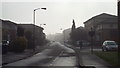
Oxley Close, SE1
Oxley Close in inner South East London. Housing was developed here in the 1980s, on a site previously occupied by a railway goods yard.
This image was taken on a day in April 2014 when London's air quality was particularly poor.
Image: © Malc McDonald
Taken: 1 Apr 2014
0.05 miles
3
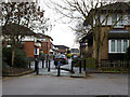
Chaucer Drive meets Oxley Close
What appears on the map to be the spine road of this housing estate is in fact broken up into several short sections, each separately named with its own independent access from Rolls Road. This is the eastern end of Chaucer Drive where it joins Oxley Close. The barriers are 'permeable' to allow cyclists and pedestrians along the full length of the road, part of the London Cycle Network. For the next such point along the road, see Image
The estate is on the site of the former Bricklayers Arms railway goods yard.
Image: © Stephen Craven
Taken: 25 Jan 2014
0.05 miles
4
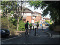
Quietway improvements (1)
Where Chaucer Drive meets Oxley Close, the former forest of bollards Image was replaced around April 2015 with a simpler arrangement and more signage to indicate that it is part of the London Cycle Network (and the new "quietway" from Waterloo to Greenwich).
Image: © Stephen Craven
Taken: 10 Jul 2015
0.05 miles
6
Housing on Chaucer Drive
The roads on this estate are all named after well known writers.
Image: © Stephen Craven
Taken: 25 Jan 2014
0.05 miles
7
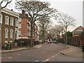
Lynton Road, Bermondsey
At the junction with Chaucer Drive, as the sign shows. The brick flats on the left are part of Stansfield House on the Longfield estate.
Image: © Derek Harper
Taken: 9 Feb 2011
0.06 miles
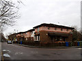
8
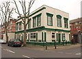
Havelock House, Bermondsey
Formerly the Havelock Arms, and now flats. On the corner of Fort Road and Balaclava Road.
Image: © Derek Harper
Taken: 9 Feb 2011
0.10 miles
9
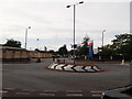
Mini roundabout near Tesco Supermarket
This roundabout is on Rolls Road (from South Bermondsey). Mandela Way leads left towards the A2 Old Kent Road, or right towards an industrial estate.
Opposite is an exit/entrance to the large supermarket car park.
Image: © David Anstiss
Taken: 25 Sep 2011
0.10 miles
10
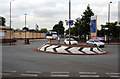
Southwark: Roundabout at west end of Rolls Road
To the left is Humphrey Street.
Image: © Dr Neil Clifton
Taken: 5 Jul 2012
0.10 miles