IMAGES TAKEN NEAR TO
Lynton Road, LONDON, SE1 5LA
Introduction
This page details the photographs taken nearby to Lynton Road, SE1 5LA by members of the Geograph project.
The Geograph project started in 2005 with the aim of publishing, organising and preserving representative images for every square kilometre of Great Britain, Ireland and the Isle of Man.

There are currently over 7.5m images from over14,400 individuals and you can help contribute to the project by visiting https://www.geograph.org.uk
Image Map
Images are licensed for reuse under creativecommons.org/licenses/by-sa/2.0
Notes
- Clicking on the map will re-center to the selected point.
- The higher the marker number, the further away the image location is from the centre of the postcode.
Image Listing (85 Images Found)
Images are licensed for reuse under creativecommons.org/licenses/by-sa/2.0
Image
Details
Distance
1
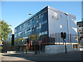
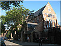
City of London Academy
The Academy is not actually in the City of London - the name reflects the Corporation of London's input as sponsors. It is a state secondary school situated on the junction of Lynton Road and St James Road, Bermondsey, and the present buildings opened in 2005. Their website is http://www.cityacademy.co.uk/
Image: © Stephen Craven
Taken: 19 Aug 2009
0.01 miles
2
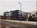
City of London Academy, Bermondsey
It is a state secondary school situated on the junction of Lynton Road and St James Road (in front).
See http://en.wikipedia.org/wiki/City_of_london_academy for more details about the academy.
Image: © David Anstiss
Taken: 25 Sep 2011
0.03 miles
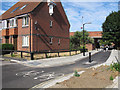
3
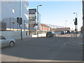
St James's Road, Bermondsey - bridge approach
The road rises at this point to the bridge over the route of former railway line - for a view of the bridge from the road underneath see Image The building at left is a school Image
Image: © Stephen Craven
Taken: 19 Aug 2009
0.03 miles
4
John Bull Arch, Southwark Park Road, Rotherhithe, London, SE16
Photo taken opposite Raymouth Road with Drummond Road just past the petrol station. On Thursday 26-10-1944 a VII rocket bomb hit the bridge killing 8 people. Temporary bridge constructed and then on Sunday 05-11-1944 another VII hit the bridge killing 3 people and destroying the temporary structure. Bridge took its name from the 'John Bull' pub that was under the bridge and on the right in Bermondsey.
Image: © Chris Lordan
Taken: 23 Sep 2009
0.03 miles
5
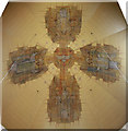
St Philip & St Mark, Avondale Square, Camberwell - Roof
By John Hayward
Image: © John Salmon
Taken: 16 Feb 2011
0.03 miles
6
St Augustine's Court, Lynton Road, Bermondsey
It would be hard to disguise the fact that this 'court' was originally a church. In fact, St Augustine's was one of the largest churches in South London, built in 1875-1883 to the designs of Henry Jarvis, and seated 950 people. That was one reason for its proposed closure when the parish merged with that of St Anne Image in 1970 but in fact it was not formally declared redundant by the Church of England until 1995. After a short period of lease to another Christian group it was sold in 2005 for conversion to residential use. The building remains listed grade 2*.
Image: © Stephen Craven
Taken: 19 Aug 2009
0.04 miles
7
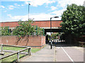
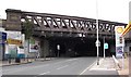
St James's Road bridge
The bridge formerly crossed a railway line, but the railway land has been developed for housing since it closed in 1981 and the transport route under the bridge is now simply a cycle path linking Abercorn Way and Stevenson Crescent.
Image: © Stephen Craven
Taken: 18 Jul 2009
0.07 miles
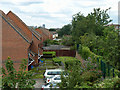
8
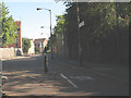
Stevenson Crescent, South Bermondsey
The Crescent is one of several residential streets occupying former railway land. This photo is of a spur at its northern end that becomes a cycle path linking to Lynton Road.
Image: © Stephen Craven
Taken: 19 Aug 2009
0.08 miles
9
Quietway improvements (3)
Where Abercorn Way meets Stevenson Crescent under the St James's Road bridge, the former cycle barrier Image was replaced around April 2015 with a wider gap to allow cyclists through at higher speeds and minimal bollards to keep motor vehicles out, and more signage to indicate that it is part of the London Cycle Network (and the new "quietway" from Waterloo to Greenwich).
The bridge formerly crossed a railway line, but the railway land has been developed for housing since it closed in 1981.
Image: © Stephen Craven
Taken: 10 Jul 2015
0.08 miles
10
There was a railway here once
A view from the bridge which formerly spanned nine tracks leading to Bricklayers Arms goods and locomotive depots. This large area occupied by even more sidings is now housing. The wall topped with fencing on the right appears to be the original wall along the northern boundary of the railway yards.
Image: © Robin Webster
Taken: 23 Jul 2011
0.09 miles