IMAGES TAKEN NEAR TO
Mawbey Place, LONDON, SE1 5JL
Introduction
This page details the photographs taken nearby to Mawbey Place, SE1 5JL by members of the Geograph project.
The Geograph project started in 2005 with the aim of publishing, organising and preserving representative images for every square kilometre of Great Britain, Ireland and the Isle of Man.

There are currently over 7.5m images from over14,400 individuals and you can help contribute to the project by visiting https://www.geograph.org.uk
Image Map
Images are licensed for reuse under creativecommons.org/licenses/by-sa/2.0
Notes
- Clicking on the map will re-center to the selected point.
- The higher the marker number, the further away the image location is from the centre of the postcode.
Image Listing (148 Images Found)
Images are licensed for reuse under creativecommons.org/licenses/by-sa/2.0
Image
Details
Distance
1
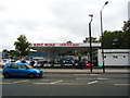
Mawbey Road, SE1
Mawbey Road, just off Old Kent Road in inner south east London.
This image was taken on a morning when air quality was particularly poor. What looks like mist was in fact pollution.
Image: © Malc McDonald
Taken: 1 Apr 2014
0.03 miles
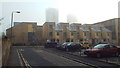
2
Mawbey House from Kent House courtyard
All part of the Mawbey Estate, (guessing) council housing of the 1950s.
Image: © Robin Stott
Taken: 25 Aug 2013
0.03 miles
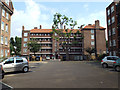
3
Bermondsey: Mawbey House
An attractive apartment block which I had an opportunity to photograph while stuck at traffic lights in Old Kent Road, happening to come to a halt on the block's axis of symmetry.
Image: © Chris Downer
Taken: 9 Jul 2011
0.04 miles
4
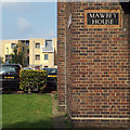
Corner of Mawbey House with bespoke tiled name panel
Mawbey House forms part of the Mawbey Estate, (guessing) council housing of the 1950s.
Image: © Robin Stott
Taken: 25 Aug 2013
0.05 miles
5
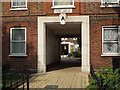
Entrance A, Kent House, Old Kent Road
Kent House forms part of the Mawbey Estate, (guessing) council housing of the 1950s.
Image: © Robin Stott
Taken: 25 Aug 2013
0.05 miles
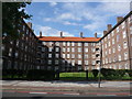
6
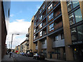
Coopers Road
New housing just off the Old Kent Road. For Success House in the foreground see Image
Image: © Stephen Craven
Taken: 22 Jul 2015
0.05 miles
7

Art Everywhere No 6, Old Kent Road bus shelter
No 6 was 'The Snack Bar' by Edward Burra, 1930, in the Tate Gallery.
Image: © Robin Stott
Taken: 25 Aug 2013
0.06 miles
8
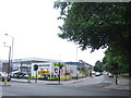
Tyre garage, Old Kent Road
A tyre garage on the corner of Old Kent Road and Glengall Road.
Planning permission was granted in 2011 for a housing development on this site. This view may therefore change significantly.
Image: © Malc McDonald
Taken: 30 May 2011
0.06 miles
9
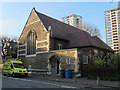
St Philip's church hall, Avondale Square
The church itself Image was rebuilt in 1963, after being bombed in World War 2, but the adjacent hall (which with its large window looks much like a Victorian church) seems to have survived the war. It is now used by a wide range of community groups (the sound of singing practice was drifting out of the door as I passed). See also Image
Image: © Stephen Craven
Taken: 14 Apr 2015
0.07 miles