IMAGES TAKEN NEAR TO
Lynton Road, SE1 5DE
Introduction
This page details the photographs taken nearby to Lynton Road, SE1 5DE by members of the Geograph project.
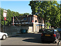
The Geograph project started in 2005 with the aim of publishing, organising and preserving representative images for every square kilometre of Great Britain, Ireland and the Isle of Man.

There are currently over 7.5m images from over14,400 individuals and you can help contribute to the project by visiting https://www.geograph.org.uk
Image Map
Images are licensed for reuse under creativecommons.org/licenses/by-sa/2.0
Notes
- Clicking on the map will re-center to the selected point.
- The higher the marker number, the further away the image location is from the centre of the postcode.
Image Listing (102 Images Found)
Images are licensed for reuse under creativecommons.org/licenses/by-sa/2.0
Image
Details
Distance
1
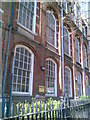
Galleywall Road School (detail)
A standard School Board for London design from the early 20th century, now used by Southwark Council as a "spare" school - a site available to accommodate other schools whilst their buildings are refurbished, and so forth.
Image: © Helena Hilton
Taken: 9 Apr 2008
0.08 miles
2
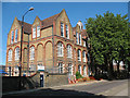
Southwark Park School
A typical late-19th century 3-storey primary school on Galleywall Road. See also Image
Image: © Stephen Craven
Taken: 21 May 2011
0.08 miles
3
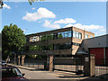
Church of England Records Centre
This building on Galleywall Road houses a national archive of church deeds, etc.
Image: © Stephen Craven
Taken: 21 May 2011
0.09 miles
4
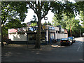
Dan's cafe
A refreshment facility on the corner of Galleywall Road and Hyson Road.
Image: © Stephen Craven
Taken: 21 May 2011
0.10 miles
5
St George's Tavern, Camilla Road, Bermondsey
Image: © Stephen Craven
Taken: 19 Aug 2009
0.10 miles
6
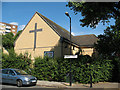
Manor Methodist Church, Bermondsey - rear
A cross built into the brickwork adorns the rear of the church on Roseberry Street. For a similar view see Image
Image: © Stephen Craven
Taken: 21 May 2011
0.10 miles
7
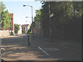
Stevenson Crescent, South Bermondsey
The Crescent is one of several residential streets occupying former railway land. This photo is of a spur at its northern end that becomes a cycle path linking to Lynton Road.
Image: © Stephen Craven
Taken: 19 Aug 2009
0.10 miles
8
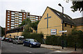
Roseberry Street
Seen from the junction with Galleywall Road. On the right is The Manor Methodist Church, home of the 16th Bermondsey Scouts.
Image: © Martin Addison
Taken: 22 Oct 2010
0.10 miles
10
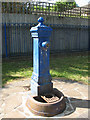
Drinking fountain in Shuttleworth Park
A historic cast iron fountain; I don't know whether it is still operational.
Image: © Stephen Craven
Taken: 21 May 2011
0.11 miles