IMAGES TAKEN NEAR TO
Dragon Road, LONDON, SE15 6QU
Introduction
This page details the photographs taken nearby to Dragon Road, SE15 6QU by members of the Geograph project.
The Geograph project started in 2005 with the aim of publishing, organising and preserving representative images for every square kilometre of Great Britain, Ireland and the Isle of Man.

There are currently over 7.5m images from over14,400 individuals and you can help contribute to the project by visiting https://www.geograph.org.uk
Image Map
Images are licensed for reuse under creativecommons.org/licenses/by-sa/2.0
Notes
- Clicking on the map will re-center to the selected point.
- The higher the marker number, the further away the image location is from the centre of the postcode.
Image Listing (176 Images Found)
Images are licensed for reuse under creativecommons.org/licenses/by-sa/2.0
Image
Details
Distance
1
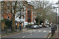
St George's Way
The southern side of the road is here lined with modern flats. View from just south of the former Surrey Canal Footbridge.
Image: © David Martin
Taken: 29 Jan 2023
0.03 miles
2
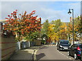
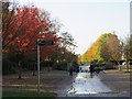
Watling Street, North Peckham
Autumn colour on Watling Street, a residential street in North Peckham.
Image: © Malc McDonald
Taken: 26 Oct 2020
0.05 miles
3
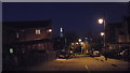
Pearse Street, North Peckham, after dark
Pearse Street in North Peckham, on a February evening after darkness has fallen. This street was created during regeneration of North Peckham during the early years of the 21st Century.
The lights in the distance are The Shard, which was western Europe's tallest building at the time this image was taken, and several other towers in the City of London. In front of The Shard is a high-rise block of flats, part of the Aylesbury Estate. The Aylesbury Estate is due to be redeveloped.
Image: © Malc McDonald
Taken: 9 Feb 2014
0.06 miles
4
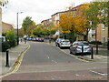
Dragon Road, North Peckham
Autumn tree colour in Dragon Road, a residential road in North Peckham.
Image: © Malc McDonald
Taken: 26 Oct 2020
0.07 miles
5
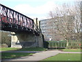
Burgess Park, canal footbridge
A footbridge over the former Surrey Canal. The canal was built to serve light industry which was once located here. Once the industries closed down, the canal fell into disuse and was later filled in. Its route is now a path running through Burgess Park, which was created in the 20th Century in this former industrial area.
In the background is tower block of the Aylesbury Estate, an inner city housing estate developed in the 1960s and 1970s.
Image: © Malc McDonald
Taken: 20 Feb 2010
0.07 miles
6
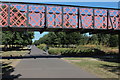
Bridge over the former Surrey Canal, Burgess Park
Image: © Robin Stott
Taken: 25 Aug 2013
0.07 miles
7
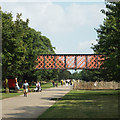
Burgess Park Bridge
This is locally known as the "bridge to nowhere". It once spanned the Grand Surrey canal basin which was abandoned in the 1940s and filled in during the 1960s. Burgess Park now occupies the site of the old canal.
Image: © Robert Eva
Taken: 15 Aug 2016
0.07 miles
8
Autumn colour in Burgess Park, near Camberwell
An image taken in Burgess Park on a November day. Leaves were turning red and gold, and falling from the trees.
The path heading straight ahead follows the route of the former Surrey Canal.
Image: © Malc McDonald
Taken: 10 Nov 2019
0.07 miles
9
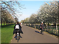
Cyclists passing in Burgess Park
The main east-west path through the park, on the line of the old Surrey Canal, is well used by cyclists.
Image: © Stephen Craven
Taken: 14 Apr 2015
0.07 miles
10
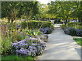
Autumn flowers in Burgess Park
Violet-coloured flowers in Burgess Park, in inner south east London. This image was taken during the month of October.
Image: © Malc McDonald
Taken: 19 Oct 2020
0.07 miles