IMAGES TAKEN NEAR TO
St. Georges Way, LONDON, SE15 6PL
Introduction
This page details the photographs taken nearby to St. Georges Way, SE15 6PL by members of the Geograph project.
The Geograph project started in 2005 with the aim of publishing, organising and preserving representative images for every square kilometre of Great Britain, Ireland and the Isle of Man.

There are currently over 7.5m images from over14,400 individuals and you can help contribute to the project by visiting https://www.geograph.org.uk
Image Map
Images are licensed for reuse under creativecommons.org/licenses/by-sa/2.0
Notes
- Clicking on the map will re-center to the selected point.
- The higher the marker number, the further away the image location is from the centre of the postcode.
Image Listing (139 Images Found)
Images are licensed for reuse under creativecommons.org/licenses/by-sa/2.0
Image
Details
Distance
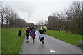
1
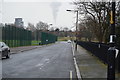
Burgess Park
Photo taken near Sumner Road and the Trafalgar Bridge which used to go over a canal. See the historic map for a contrast -- the area was much more built up then.
Image: © Danny P Robinson
Taken: 14 Jan 2007
0.05 miles
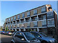
2
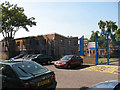
Southwark Inclusive Learning Centre
An educational facility on Davey Street, Peckham.
Image: © Stephen Craven
Taken: 4 Jun 2010
0.05 miles
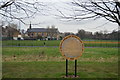
3
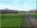
Burgess Park on a sunny day
Looking west along the central path through the park, which is a well-used cycle route on the alignment of the former Surrey Canal. In the background is the former St George's church Image
Image: © Stephen Craven
Taken: 21 Oct 2014
0.05 miles
5
Site of the former All Saints church, North Peckham
This four-storey block of flats on the south side of Davey Street now stands on the site of the former church, which occupied the site from c.1892 to c.1952. It was not destroyed but taken down and rebuilt to a different design as Biggin Hill, St Mark (Rochester Diocese) Image in 1959. The parish was united in 1956 with that of St Andrew. This All Saints is not to be confused with the present church of the same name on Blenheim Grove Image
Image: © Stephen Craven
Taken: 14 Apr 2015
0.07 miles
7
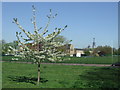
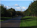
Springtime in Burgess Park
Burgess Park in South London has been created on land which was formerly a canal flanked by factories, warehouses and residential streets.
In the foreground is a cherry tree in blossom. In the distance, a tall building often called "The Shard" is being built. When completed, it will be the tallest building in the European Union.
Image: © Malc McDonald
Taken: 8 Apr 2011
0.07 miles
8
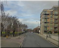
Sumner Road, Peckham
This road runs from Peckham centre to Old Kent Road. At the Peckham end, it is Peckham Hill St, at the Old Kent Road end Trafalgar Avenue and there is this section in the middle where it is Sumner Road.
Image: © Robert Eva
Taken: 1 Jan 2018
0.08 miles
9
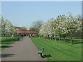
Former canal path, Burgess Park
Springtime in Burgess Park, with cherry trees in bossom.
The park occupies land which was formerly streets, housing and light industry flanking a canal. The path in this image follows the route of the canal, which was filled in in the 1980s. The footbridge survives as a reminder that the canal used to be here.
Image: © Malc McDonald
Taken: 8 Apr 2011
0.09 miles