IMAGES TAKEN NEAR TO
Ebley Close, LONDON, SE15 6BE
Introduction
This page details the photographs taken nearby to Ebley Close, SE15 6BE by members of the Geograph project.
The Geograph project started in 2005 with the aim of publishing, organising and preserving representative images for every square kilometre of Great Britain, Ireland and the Isle of Man.

There are currently over 7.5m images from over14,400 individuals and you can help contribute to the project by visiting https://www.geograph.org.uk
Image Map
Images are licensed for reuse under creativecommons.org/licenses/by-sa/2.0
Notes
- Clicking on the map will re-center to the selected point.
- The higher the marker number, the further away the image location is from the centre of the postcode.
Image Listing (153 Images Found)
Images are licensed for reuse under creativecommons.org/licenses/by-sa/2.0
Image
Details
Distance
1
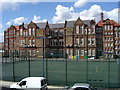
Gloucester Primary School, Peckham North
Built in 1870s as Gloucester Road School, just south of Burgess Park - famous alumni include Lord Harris, founder of Carpetright.
Image: © Phil
Taken: 24 Apr 2008
0.05 miles
2
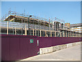
New buildings for Tuke School
Until 2010, Tuke Special School was situated on Woods Road Image
As of 2010 this replacement building was in construction, due to open in September 2010. It will "provide specialist facilities for all students with Profound and Complex Learning difficulties" according to the school's website http://www.tukeschool.co.uk/ .
Image: © Stephen Craven
Taken: 4 Jun 2010
0.06 miles
3
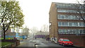
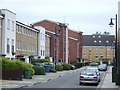
Daniel Gardens, SE15
This image of Daniel Gardens, in North Peckham, was taken one morning in April 2014 when London's air quality was particularly poor. What looks like mist is in fact pollution.
Image: © Malc McDonald
Taken: 1 Apr 2014
0.08 miles
4
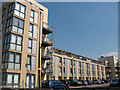
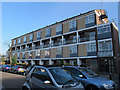
Gately Court
A newly completed apartment (c.2009/10) on Samuel Street, Peckham.
Image: © Stephen Craven
Taken: 4 Jun 2010
0.08 miles
5
Burcher Gale Grove, Peckham
Burcher Gale Grove is a residential street created in around 2005, as part of the regeneration of the North Peckham estate. The buildings are a mix of houses and apartment blocks.
Image: © Malc McDonald
Taken: 23 Jun 2012
0.09 miles
6
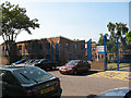
Southwark Inclusive Learning Centre
An educational facility on Davey Street, Peckham.
Image: © Stephen Craven
Taken: 4 Jun 2010
0.09 miles
7
Site of the former All Saints church, North Peckham
This four-storey block of flats on the south side of Davey Street now stands on the site of the former church, which occupied the site from c.1892 to c.1952. It was not destroyed but taken down and rebuilt to a different design as Biggin Hill, St Mark (Rochester Diocese) Image in 1959. The parish was united in 1956 with that of St Andrew. This All Saints is not to be confused with the present church of the same name on Blenheim Grove Image
Image: © Stephen Craven
Taken: 14 Apr 2015
0.09 miles
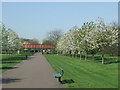
9
Former canal path, Burgess Park
Springtime in Burgess Park, with cherry trees in bossom.
The park occupies land which was formerly streets, housing and light industry flanking a canal. The path in this image follows the route of the canal, which was filled in in the 1980s. The footbridge survives as a reminder that the canal used to be here.
Image: © Malc McDonald
Taken: 8 Apr 2011
0.10 miles
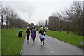
10
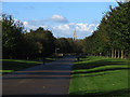
Burgess Park on a sunny day
Looking west along the central path through the park, which is a well-used cycle route on the alignment of the former Surrey Canal. In the background is the former St George's church Image
Image: © Stephen Craven
Taken: 21 Oct 2014
0.10 miles