IMAGES TAKEN NEAR TO
SE15 5PW
Introduction
This page details the photographs taken nearby to SE15 5PW by members of the Geograph project.
The Geograph project started in 2005 with the aim of publishing, organising and preserving representative images for every square kilometre of Great Britain, Ireland and the Isle of Man.

There are currently over 7.5m images from over14,400 individuals and you can help contribute to the project by visiting https://www.geograph.org.uk
Image Map
Images are licensed for reuse under creativecommons.org/licenses/by-sa/2.0
Notes
- Clicking on the map will re-center to the selected point.
- The higher the marker number, the further away the image location is from the centre of the postcode.
Image Listing (103 Images Found)
Images are licensed for reuse under creativecommons.org/licenses/by-sa/2.0
Image
Details
Distance
1
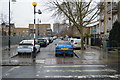
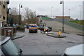
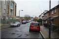
Kelly Avenue, Peckham
This site was previously part of the large and troubled North Peckham Estate, a sprawling local authority housing estate. Part of the estate was demolished and redeveloped in the early years of the 21st Century, however several chimneys still stand. One is visible in the background to the left of the image.
Kelly Avenue, pictured here, was one option for the route of the Cross River Tram, a scheme promoted by London's previous Mayor. The tram scheme was abandoned by the present Mayor shortly after he took office in 2008.
Image: © Malc McDonald
Taken: 17 Oct 2010
0.04 miles
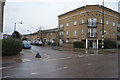
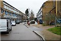
8
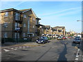
Sumner Road, SE15
At the corner of Lisford Street. These flats and houses have been built on the site of the Sumner Estate, mostly 1930s GLC-style 5 storey tenement blocks, demolished in the early 1990s.
Image: © Danny P Robinson
Taken: 14 Jan 2007
0.09 miles