IMAGES TAKEN NEAR TO
Stopes Street, LONDON, SE15 5GE
Introduction
This page details the photographs taken nearby to Stopes Street, SE15 5GE by members of the Geograph project.
The Geograph project started in 2005 with the aim of publishing, organising and preserving representative images for every square kilometre of Great Britain, Ireland and the Isle of Man.

There are currently over 7.5m images from over14,400 individuals and you can help contribute to the project by visiting https://www.geograph.org.uk
Image Map
Images are licensed for reuse under creativecommons.org/licenses/by-sa/2.0
Notes
- Clicking on the map will re-center to the selected point.
- The higher the marker number, the further away the image location is from the centre of the postcode.
Image Listing (113 Images Found)
Images are licensed for reuse under creativecommons.org/licenses/by-sa/2.0
Image
Details
Distance
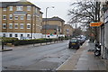
6
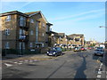
Sumner Road, SE15
At the corner of Lisford Street. These flats and houses have been built on the site of the Sumner Estate, mostly 1930s GLC-style 5 storey tenement blocks, demolished in the early 1990s.
Image: © Danny P Robinson
Taken: 14 Jan 2007
0.07 miles
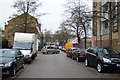
7
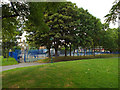
Playground, open space by Commercial Way
Image: © Robin Stott
Taken: 26 Aug 2013
0.07 miles