IMAGES TAKEN NEAR TO
Blenheim Grove, LONDON, SE15 4QS
Introduction
This page details the photographs taken nearby to Blenheim Grove, SE15 4QS by members of the Geograph project.
The Geograph project started in 2005 with the aim of publishing, organising and preserving representative images for every square kilometre of Great Britain, Ireland and the Isle of Man.

There are currently over 7.5m images from over14,400 individuals and you can help contribute to the project by visiting https://www.geograph.org.uk
Image Map
Images are licensed for reuse under creativecommons.org/licenses/by-sa/2.0
Notes
- Clicking on the map will re-center to the selected point.
- The higher the marker number, the further away the image location is from the centre of the postcode.
Image Listing (106 Images Found)
Images are licensed for reuse under creativecommons.org/licenses/by-sa/2.0
Image
Details
Distance
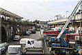
1
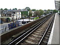
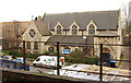
Blenheim Grove from Peckham Rye station
Peckham Rye railway station opened on 1st December 1865 for London, Chatham & Dover Railway trains and on 13th August 1886 for London Brighton & South Coast Railway trains. It was designed by Charles Henry Driver (1832–1900), the architect of Abbey Mills and Crossness Pumping Stations, who also designed the grade II listed Denmark Hill and Battersea Park stations between here and Victoria. Peckham Rye is almost two separate stations, linked by a booking hall. This view is from the southern (London, Chatham & Dover Railway) platform and looks down on Blenheim Grove.
Image: © Marathon
Taken: 31 Aug 2011
0.01 miles
2
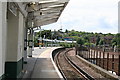
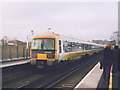
Peckham Rye station
Peckham Rye is an unusual station, being really two separate stations, since 1923 combined into one. The more northerly pair of platforms, now 3 and 4, lie on the ex-LCD line from Victoria which (originally) ran to Crystal Palace (High Level) and Greenwich Park. At the eastern end, both these lines have been closed and now the line goes to Lewisham. The southerly part of the station (platforms 1 and 2) is an island platform, (originally this part had side platforms as well) on the ex-LBSC South London line.
This photograph is taken on the South London side looking westwards with a Class 455 unit just having departed on its way to Victoria.
Image: © Dr Neil Clifton
Taken: 18 Jun 2012
0.02 miles
3
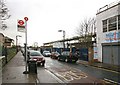
Blenheim Grove, London SE15
Peckham Rye Railway Station visible
Image: © John Salmon
Taken: 21 Feb 2010
0.03 miles
5
Between The Platforms
Peckham Rye is a station with two separate sides. Initially it was served by the London, Chatham & Dover Railway from December 1865 - tracks to the right. The London, Brighton & South Coast Railway connected to the station in August of 1866 - tracks on the left. Even today, knowing which side of the station you need for your journey is essential. London Overground and Southern on the Left, Southeastern and Thames link on the right. The arches carrying the tracks and platforms with the enclosed area between have become a home for light industry and small business.
Image: © Martin Addison
Taken: 16 Apr 2015
0.04 miles
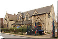
6
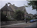
All Saints Church, Peckham
The official name of this church is All Saints, Camberwell, but apart from administrative issues with the Diocese, it is always known as All Saints Peckham.
Image: © PAUL FARMER
Taken: 5 Jun 2011
0.04 miles
7
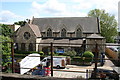
Peckham: All Saints Church
Seen from Platform 1 at Peckham Rye station
Image: © Dr Neil Clifton
Taken: 18 Jun 2012
0.04 miles
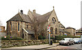
9
All Saints, Blenheim Grove
From Peckam Rye Station
Image: © John Salmon
Taken: 24 Jan 2014
0.04 miles
10
Commuters at Peckham Rye
The morning rush-hour at Peckham Rye. A Slade Green to Victoria service leaves platform 3 while a good number of commuters are also waiting for a Blackfriars to Sevenoaks service at Platform 4. Platforms 1 and 2 are on the separate lines from London Bridge to Dulwich and Cyrstal Palace.
Image: © Stephen Craven
Taken: 28 Feb 2003
0.04 miles