IMAGES TAKEN NEAR TO
Buchan Road, LONDON, SE15 3HG
Introduction
This page details the photographs taken nearby to Buchan Road, SE15 3HG by members of the Geograph project.
The Geograph project started in 2005 with the aim of publishing, organising and preserving representative images for every square kilometre of Great Britain, Ireland and the Isle of Man.

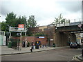
There are currently over 7.5m images from over14,400 individuals and you can help contribute to the project by visiting https://www.geograph.org.uk
Image Map
Images are licensed for reuse under creativecommons.org/licenses/by-sa/2.0
Notes
- Clicking on the map will re-center to the selected point.
- The higher the marker number, the further away the image location is from the centre of the postcode.
Image Listing (156 Images Found)
Images are licensed for reuse under creativecommons.org/licenses/by-sa/2.0
Image
Details
Distance
2
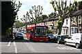
Nunhead: Kimberley Avenue
Looking west. The London Central single-decker is on local route P12, which runs between Honor Oak Park and Surrey Quays by a very complicated (and interesting) route.
Image: © Dr Neil Clifton
Taken: 18 Jun 2012
0.04 miles


5
Nunhead: The Sign Remains...
Looking north towards the railway bridge carrying the ex-LCD railway, the only remnant of the former 'Railway Tavern' is its very faded sign.
Image: © Dr Neil Clifton
Taken: 18 Jun 2012
0.05 miles
6
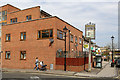
Where Once Stood...
...The Railway Tavern. Replaced by modern housing, the pub closed in 2003 and was demolished circa 2006. Only the decaying sign remains to recall its existence.
Image: © Martin Addison
Taken: 16 Apr 2015
0.05 miles
8
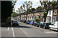
Nunhead: Kimberley Avenue
Looking west along this pleasant tree-lined road
Image: © Dr Neil Clifton
Taken: 18 Jun 2012
0.05 miles
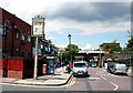
9
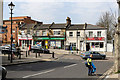
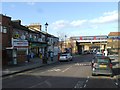
Shops on Gibbon Road
A short parade of shops next to the entrance to Nunhead railway station. Originally each would have been an individual premises but two have merged to form a Londis supermarket. A third has ceased trading and become a private dwelling. At the left hand end of the parade the original building - a public house - has been demolished and replaced by modern housing. In the foreground, a council worker collects litter on Oakdale Road.
Image: © Martin Addison
Taken: 16 Apr 2015
0.06 miles
10
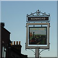
Railway Tavern sign
The Railway Tavern once stood close to Nunhead station but it has been long closed and replaced by housing. Only the old sign remained, looking increasingly weathered, but now a brand new one has been put up.
Image: © Robert Eva
Taken: 19 Jan 2017
0.06 miles