IMAGES TAKEN NEAR TO
Athenlay Road, LONDON, SE15 3EL
Introduction
This page details the photographs taken nearby to Athenlay Road, SE15 3EL by members of the Geograph project.
The Geograph project started in 2005 with the aim of publishing, organising and preserving representative images for every square kilometre of Great Britain, Ireland and the Isle of Man.

There are currently over 7.5m images from over14,400 individuals and you can help contribute to the project by visiting https://www.geograph.org.uk
Image Map
Images are licensed for reuse under creativecommons.org/licenses/by-sa/2.0
Notes
- Clicking on the map will re-center to the selected point.
- The higher the marker number, the further away the image location is from the centre of the postcode.
Image Listing (84 Images Found)
Images are licensed for reuse under creativecommons.org/licenses/by-sa/2.0
Image
Details
Distance
2
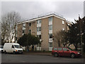
Flats on Brenchley Gardens
One of several similar blocks along the western side of the road.
Image: © Stephen Craven
Taken: 18 Jan 2015
0.06 miles
3
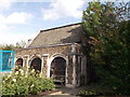
Waiting Room, Camberwell New Cemetery
Grade II listed Cemetery waiting room, now utility shed.
Image: © David Anstiss
Taken: 25 Sep 2011
0.09 miles
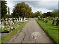
4
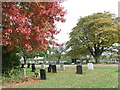
Camberwell New Cemetery
In the 1850s the Parish of Camberwell was in desperate need of new burial space. The Camberwell Burial Board was set up to find an answer to the problem and copying the instant success of the nearby Nunhead Cemetery, they bought 30 acres of meadowland and established the 'Burial Ground of St Giles Camberwell'. The first interment took place on 3rd July 1856. Over 30,000 burials took place in the subsequent 30 years. In 1874 the cemetery was expanded by a further seven acres.
At the turn of the 20th century it was recognised that the Old Cemetery would soon be full. The land for Camberwell New Cemetery was purchased in three lots totalling 68 acres in 1901. Following its acquisition much of the land was rented out for other uses, including a golf club and a fireworks factory. In 1926 the first part of the land was laid out as a cemetery and the first interment took place on 23rd May 1927. However, large portions remain unused for burials and some of this land is now a recreation ground.
More information about both cemeteries can be found at https://en.wikipedia.org/wiki/Camberwell_Cemeteries
This view is from near the entrance in Brenchley Gardens.
Image: © Marathon
Taken: 18 Oct 2015
0.09 miles
5
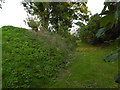
The old Crystal Palace High Level line
The London, Chatham & Dover Railway opened the line from Nunhead to Crystal Palace High Level in 1865 to serve the Crystal Palace, which had been rebuilt on Sydenham Hill some ten years previously. Unfortunately the Crystal Palace was in decline as a visitor attraction by the end of the 19th century and this, coupled with the fact that the line passed through an area which was largely undeveloped well into the 20th century, meant that the line had very low passenger usage. It finally closed in 1954.
Once dismantling of the track had been completed, the entire railway land between Nunhead and Crystal Palace was bought by the London County Council who passed it on to local councils for housing and open space development. This was the origin of the attractive open space just behind where I am standing of Brenchley Gardens - see http://www.geograph.org.uk/photo/2636206
This view looks northwards along the embankment of the old track towards Nunhead. It is seen from Kelvington Road.
Image: © Marathon
Taken: 18 Oct 2015
0.09 miles
6
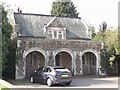
Lodge, Camberwell New Cemetery
Grade II listed Lodge building near the gateway to the large cemetery.
See http://www.britishlistedbuildings.co.uk/en-470688-lodge-camberwell-new-cemetery-camberwell for more details about the building.
Image: © David Anstiss
Taken: 25 Sep 2011
0.09 miles
7
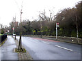
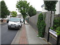
Bus stops on Brenchley Gardens
Bus stops in each direction.
Image: © Stephen Craven
Taken: 18 Jan 2015
0.11 miles
9
Camberwell New Cemetery
In the 1850s the Parish of Camberwell was in desperate need of new burial space. The Camberwell Burial Board was set up to find an answer to the problem and copying the instant success of the nearby Nunhead Cemetery, they bought 30 acres of meadowland and established the 'Burial Ground of St Giles Camberwell'. The first interment took place on 3rd July 1856. Over 30,000 burials took place in the subsequent 30 years. In 1874 the cemetery was expanded by a further seven acres.
At the turn of the 20th century it was recognised that the Old Cemetery would soon be full. The land for Camberwell New Cemetery was purchased in three lots totalling 68 acres in 1901. Following its acquisition much of the land was rented out for other uses, including a golf club and a fireworks factory. In 1926 the first part of the land was laid out as a cemetery and the first interment took place on 23rd May 1927. However, large portions remain unused for burials and some of this land is now a recreation ground.
More information about both cemeteries can be found at https://en.wikipedia.org/wiki/Camberwell_Cemeteries
In this view One Tree Hill can be seen in the distance.
Image: © Marathon
Taken: 18 Oct 2015
0.12 miles
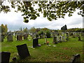
10
Camberwell New Cemetery
In the 1850s the Parish of Camberwell was in desperate need of new burial space. The Camberwell Burial Board was set up to find an answer to the problem and copying the instant success of the nearby Nunhead Cemetery, they bought 30 acres of meadowland and established the 'Burial Ground of St Giles Camberwell'. The first interment took place on 3rd July 1856. Over 30,000 burials took place in the subsequent 30 years. In 1874 the cemetery was expanded by a further seven acres.
At the turn of the 20th century it was recognised that the Old Cemetery would soon be full. The land for Camberwell New Cemetery was purchased in three lots totalling 68 acres in 1901. Following its acquisition much of the land was rented out for other uses, including a golf club and a fireworks factory. In 1926 the first part of the land was laid out as a cemetery and the first interment took place on 23rd May 1927. However, large portions remain unused for burials and some of this land is now a recreation ground.
More information about both cemeteries can be found at https://en.wikipedia.org/wiki/Camberwell_Cemeteries
Image: © Marathon
Taken: 18 Oct 2015
0.12 miles