IMAGES TAKEN NEAR TO
Ivydale Road, LONDON, SE15 3ED
Introduction
This page details the photographs taken nearby to Ivydale Road, SE15 3ED by members of the Geograph project.
The Geograph project started in 2005 with the aim of publishing, organising and preserving representative images for every square kilometre of Great Britain, Ireland and the Isle of Man.

There are currently over 7.5m images from over14,400 individuals and you can help contribute to the project by visiting https://www.geograph.org.uk
Image Map
Images are licensed for reuse under creativecommons.org/licenses/by-sa/2.0
Notes
- Clicking on the map will re-center to the selected point.
- The higher the marker number, the further away the image location is from the centre of the postcode.
Image Listing (83 Images Found)
Images are licensed for reuse under creativecommons.org/licenses/by-sa/2.0
Image
Details
Distance
2
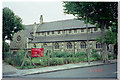
Church of St. Silas, Nunhead
Church of St. Silas, Ivydale Road, Nunhead. Photo taken 6 Sep 1998. This church has now been demolished. NB: The Grid 75 Northing runs through the site and picture could equally have been in TQ3575. For a picture of the replacement church see Image
Image: © David Wright
Taken: 6 Sep 1998
0.02 miles
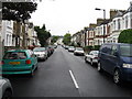
5
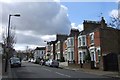
Athenlay Road, SE15
The terrace on the right is between the junction with Homeleigh and Merttins Road.
Image: © Derek Harper
Taken: 11 Mar 2011
0.07 miles
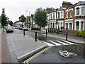
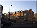
6
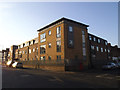
New houses on Ivydale Road (2)
A block of flats, contrasting with the contemporary town houses across the road Image
Image: © Stephen Craven
Taken: 18 Jan 2015
0.08 miles
7
On the Nunhead Footpath
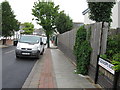
This ancient footpath runs from Brockley to Nunhead. This photo was taken on Merttins Road near the corner with Athenlay Road looking towards Brenchley Gardens. Near the centre of the picture can be seen the abutments for the old railway bridge that carried the line running to Crystal Palace High Level which closed in about 1953.
Image: © David Wright
Taken: 6 Sep 1998
0.08 miles
8
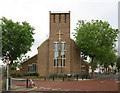
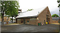
St Antony & St Silas, Ivydale Road, Nunhead
Image: © John Salmon
Taken: 14 Jul 2010
0.09 miles
9
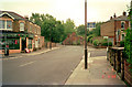
New houses on Ivydale Road (3)
The backs of these houses reveal the solar panels mounted above dormer windows.
Image: © Stephen Craven
Taken: 18 Jan 2015
0.10 miles