IMAGES TAKEN NEAR TO
Ivydale Road, LONDON, SE15 3BS
Introduction
This page details the photographs taken nearby to Ivydale Road, SE15 3BS by members of the Geograph project.
The Geograph project started in 2005 with the aim of publishing, organising and preserving representative images for every square kilometre of Great Britain, Ireland and the Isle of Man.

There are currently over 7.5m images from over14,400 individuals and you can help contribute to the project by visiting https://www.geograph.org.uk
Image Map
Images are licensed for reuse under creativecommons.org/licenses/by-sa/2.0
Notes
- Clicking on the map will re-center to the selected point.
- The higher the marker number, the further away the image location is from the centre of the postcode.
Image Listing (190 Images Found)
Images are licensed for reuse under creativecommons.org/licenses/by-sa/2.0
Image
Details
Distance
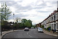
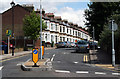
3
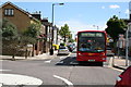
Nunhead: Ivydale Road
Looking southeast with a bus on Central London's route P12.
Image: © Dr Neil Clifton
Taken: 18 Jun 2012
0.06 miles
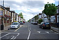
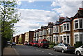
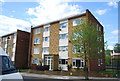
5
Nunhead: St. Asaph Road
Looking east, with excellent late Victorian terrace houses, that, it must be said, have endured much better than much of the rubbish put up in the 1960s.
Image: © Dr Neil Clifton
Taken: 18 Jun 2012
0.08 miles
7
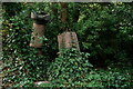
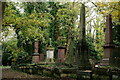
Nunhead Cemetery
Graves, down the slope from the chapel.
Image: © Peter Trimming
Taken: 17 Nov 2023
0.09 miles
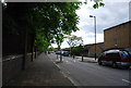
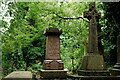
9
Nunhead Cemetery
Graves beside one of the main paths, close to the chapel.
Image: © Peter Trimming
Taken: 17 Nov 2023
0.10 miles
10
Nunhead Cemetery
Opened in 1840, one of the Magnificent Seven cemeteries in London.
Image: © Peter Trimming
Taken: 9 Jul 2024
0.10 miles