IMAGES TAKEN NEAR TO
Cheltenham Road, LONDON, SE15 3AR
Introduction
This page details the photographs taken nearby to Cheltenham Road, SE15 3AR by members of the Geograph project.
The Geograph project started in 2005 with the aim of publishing, organising and preserving representative images for every square kilometre of Great Britain, Ireland and the Isle of Man.

There are currently over 7.5m images from over14,400 individuals and you can help contribute to the project by visiting https://www.geograph.org.uk
Image Map
Images are licensed for reuse under creativecommons.org/licenses/by-sa/2.0
Notes
- Clicking on the map will re-center to the selected point.
- The higher the marker number, the further away the image location is from the centre of the postcode.
Image Listing (82 Images Found)
Images are licensed for reuse under creativecommons.org/licenses/by-sa/2.0
Image
Details
Distance
2
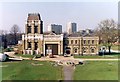
Honor Oak Pumping Station
"Honor Oak pumping station is a splendid building of 1901, with a tower topped by a French chateau roof. The tower is over the original 100-metre well, still in use. In front is Honor Oak Reservoir, the largest ever brick-built underground reservoir when completed in 1909. The roof is grassed over and is now used as a golf course."
From a Borough of Lewisham history site. http://www.lewisham.gov.uk/sitecollectiondocuments/foresthillandhonoroaksecretsleaflet.pdf
From a print. Date approximate.
Image: © Des Blenkinsopp
Taken: Unknown
0.09 miles
3
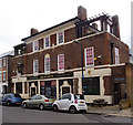
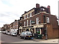
"The Ivy House" public house, Nunhead
A co-operatively owned public house - history at this http://www.ivyhousenunhead.com/about.php. Grade II listed - description at this https://historicengland.org.uk/listing/the-list/list-entry/1408530.
Architect A.E. Sewell for Truman's Brewery.
Image: © Jim Osley
Taken: 24 Nov 2016
0.11 miles
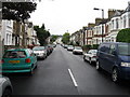
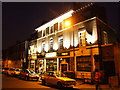
6
The Ivy House, public house, Nunhead
On Stuart Road.
Image: © David Anstiss
Taken: 25 Sep 2011
0.13 miles
7
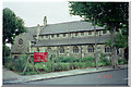
Church of St. Silas, Nunhead
Church of St. Silas, Ivydale Road, Nunhead. Photo taken 6 Sep 1998. This church has now been demolished. NB: The Grid 75 Northing runs through the site and picture could equally have been in TQ3575. For a picture of the replacement church see Image
Image: © David Wright
Taken: 6 Sep 1998
0.13 miles
9
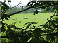
Beachcroft reservoir
With a surface area of over 6 hectares (15 acres) this reservoir takes up 6% of the grid square at its centre, yet this glimpse between the trees on Brenchley gardens is about the only view that can be had of it from a public place. The reservoir was completed in 1909 and at the time was the biggest covered service reservoir in the world, with a capacity of 56 million gallons (256 megalitres).
Image: © Stephen Craven
Taken: 8 Jun 2008
0.14 miles
10
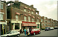
The Ivy House
The Ivy House, 40, Stuart Rd, London, SE15 3BE.
Image: © David Wright
Taken: 6 Sep 1998
0.15 miles