IMAGES TAKEN NEAR TO
Lugard Road, LONDON, SE15 2TB
Introduction
This page details the photographs taken nearby to Lugard Road, SE15 2TB by members of the Geograph project.
The Geograph project started in 2005 with the aim of publishing, organising and preserving representative images for every square kilometre of Great Britain, Ireland and the Isle of Man.

There are currently over 7.5m images from over14,400 individuals and you can help contribute to the project by visiting https://www.geograph.org.uk
Image Map
Images are licensed for reuse under creativecommons.org/licenses/by-sa/2.0
Notes
- Clicking on the map will re-center to the selected point.
- The higher the marker number, the further away the image location is from the centre of the postcode.
Image Listing (79 Images Found)
Images are licensed for reuse under creativecommons.org/licenses/by-sa/2.0
Image
Details
Distance
1
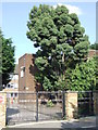
St Thomas the Apostle College, SE15
Entrance gate to St Thomas the Apostle College, on Hollydale Road, SE15.
Image: © Malc McDonald
Taken: 27 Jun 2010
0.09 miles
2
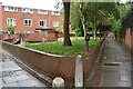
Paths and green space in the Cossall Estate
Image: © David Martin
Taken: 15 May 2022
0.10 miles
3
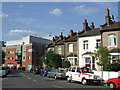
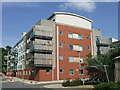
New and old, Lugard Road SE15
Contrasting new and old housing on Lugard Road, SE15.
Image: © Malc McDonald
Taken: 27 Jun 2010
0.11 miles
4
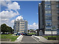
Peckham: Brayards Estate, SE15
These are 1960s built small tower blocks on the Brayards Estate managed by Southwark Council. The distant one is Walkynscroft and the near one is Ryegates. The view is taken from Caulfield Road.
Image: © Nigel Cox
Taken: 18 Jul 2007
0.13 miles
6
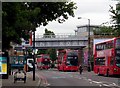
Queen's Road, Peckham and entrance to station
View westward on A202 Queens Road, the station being to the right: ex-LB&SCR London Bridge - Sutton etc. and South London Line to Victoria. (See also Image] and Image]).
Image: © Ben Brooksbank
Taken: 27 Mar 2007
0.14 miles
7
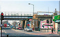
Flats on the site of the London & Brighton pub, Queen's Road
The London & Brighton pub which formerly stood on this corner can be seen in Image The sign still stands on the pavement, to the left of this image. The name is presumably derived from the London, Brighton & South Coast Railway, which ran the line through the adjacent Queen's Road Peckham station.
Image: © Christopher Hilton
Taken: 7 Oct 2015
0.15 miles
8
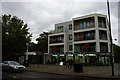
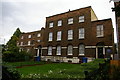
Apartment block, Lugard Road SE15
A new apartment block off Lugard Road, SE15.
Image: © Malc McDonald
Taken: 27 Jun 2010
0.15 miles
9
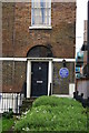
Queen's Road, Peckham: original site of the "Peckham Experiment" in health promotion
The blue plaque marks the premises in which George Scott Williamson MD (1884-1953) and Innes Hope Pearse (1889-1978) began their experiment in "growing health".
Image: © Christopher Hilton
Taken: 7 Oct 2015
0.15 miles
10
Queen's Road, Peckham: original site of the "Peckham Experiment" in health promotion
The blue plaque marks the premises in which George Scott Williamson MD (1884-1953) and Innes Hope Pearse (1889-1978) began their experiment in "growing health".
Image: © Christopher Hilton
Taken: 7 Oct 2015
0.15 miles