IMAGES TAKEN NEAR TO
Harders Road, LONDON, SE15 2QQ
Introduction
This page details the photographs taken nearby to Harders Road, SE15 2QQ by members of the Geograph project.
The Geograph project started in 2005 with the aim of publishing, organising and preserving representative images for every square kilometre of Great Britain, Ireland and the Isle of Man.

There are currently over 7.5m images from over14,400 individuals and you can help contribute to the project by visiting https://www.geograph.org.uk
Image Map
Images are licensed for reuse under creativecommons.org/licenses/by-sa/2.0
Notes
- Clicking on the map will re-center to the selected point.
- The higher the marker number, the further away the image location is from the centre of the postcode.
Image Listing (73 Images Found)
Images are licensed for reuse under creativecommons.org/licenses/by-sa/2.0
Image
Details
Distance
1
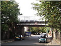
Railway bridge over Gordon Road
Gordon's Road leads from Brayards Road towards Consort Road.
The railway bridge leads between Peckham Rye to Nunhead.
Image: © David Anstiss
Taken: 25 Sep 2011
0.07 miles
2
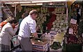
Choumert Road Market
Stall in Choumert Road market area photographed c1990
Image: © David Wright
Taken: Unknown
0.07 miles
3
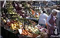
Fruit Stall - Choumert Road
Fruit stall in Choumert Road market area photographed c1990.
Image: © David Wright
Taken: Unknown
0.07 miles
4
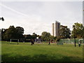
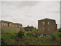
Cossall Park, Peckham Rye
This small play area and open-space is between Gordon Road and Woods Road.
In the background is a tower block on Clayton Road.
Image: © David Anstiss
Taken: 25 Sep 2011
0.08 miles
5
Nazareth Gardens, Peckham Rye
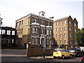
This site on Gordon Road, has quite a history. It was the site of a convent until the mid 19th century, then for over 120 years it was a hostel for homeless people. Now it has been converted into flats.
See also Image
Image: © David Anstiss
Taken: 25 Sep 2011
0.10 miles
6
Nazareth Gardens
The rear of the former homeless hostel described more fully in Image Perhaps surprisingly this elegant range of historic buildings is not listed.
Image: © Stephen Craven
Taken: 2 May 2015
0.11 miles
7
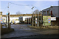
Peckham bus garage
This garage is currently operated by London Central and is situated in Blackpool Road. It opened in 1994 and replaced a similar but larger facility in Peckham High Street on part of whose site the present bus station now stands. The viaduct in the background carries the railway east of Peckham Rye station.
Image: © David Kemp
Taken: 11 Jan 2009
0.11 miles
8
Nazareth Gardens, SE15
This site has quite a history. It was the site of a convent until the mid 19th century, then for over 120 years it was a hostel for homeless people. Now it has been converted into flats.
This link tells a little more about "The Camberwell Spike" as it was once known. It is not in Camberwell, though, and there is uncertainty about how the term "Spike" for a hostel originated.
http://briandeer.com/social/london-homeless.htm
Image: © Danny P Robinson
Taken: 19 Aug 2006
0.12 miles
9
Peckham: Consort Road, SE15
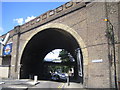
Two railway bridges for the price of one here. The near skewed arch brick bridge carries the railway line between Peckham Rye and Nunhead stations over Consort Road, while the more mundane bridge through the arch in the distance was built to take the line between Peckham Rye and Queen's Road Peckham stations over the road.
Image: © Nigel Cox
Taken: 18 Jul 2007
0.13 miles
10
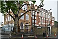
John Donne Primary School
Formerly Woods Road School, attended by my father in the 1920s.
Image: © David Martin
Taken: 15 May 2022
0.13 miles