IMAGES TAKEN NEAR TO
Hornshay Street, LONDON, SE15 1HB
Introduction
This page details the photographs taken nearby to Hornshay Street, SE15 1HB by members of the Geograph project.
The Geograph project started in 2005 with the aim of publishing, organising and preserving representative images for every square kilometre of Great Britain, Ireland and the Isle of Man.

There are currently over 7.5m images from over14,400 individuals and you can help contribute to the project by visiting https://www.geograph.org.uk
Image Map
Images are licensed for reuse under creativecommons.org/licenses/by-sa/2.0
Notes
- Clicking on the map will re-center to the selected point.
- The higher the marker number, the further away the image location is from the centre of the postcode.
Image Listing (78 Images Found)
Images are licensed for reuse under creativecommons.org/licenses/by-sa/2.0
Image
Details
Distance
1
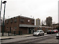
The Wheelshunters Club, Hornshay Street
You have to be a certain age to get the reference to the "Wheeltappers and Shunters Club", a fictional place in a 1970s TV series http://en.wikipedia.org/wiki/The_Wheeltappers_and_Shunters_Social_Club
In 2011 local media reported it was faced with closure, but I'm not sure whether it is still open or not.
Image: © Stephen Craven
Taken: 18 Jan 2013
0.00 miles
2
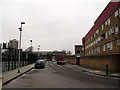
Hornshay Street
Saltwood House on the right; sports facilities (basketball and football) on the left.
Image: © Stephen Craven
Taken: 18 Jan 2013
0.03 miles
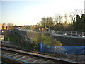
3
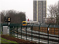
Signals turned to danger
The London Overground train in this view has just passed the four aspect signal shown in Image, turning it to red (stop); the repeater signal now shows a horizontal bar.
Image: © Stephen Craven
Taken: 18 Jan 2013
0.03 miles
4
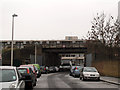
Hornshay Street railway bridge
The bridge, with a height limit of 4.5 metres, carries the South London Line (between South Bermondsey and Queens Road stations).
Image: © Stephen Craven
Taken: 18 Jan 2013
0.03 miles
5
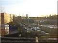
London Overground construction works, south of Surrey Canal Road, December 2011
Between Queen's Road and South Bermondsey stations, the train traveller can see new track peeling off eastwards: the formation for what will become the London Overground line from Clapham Junction onto the old East London Line towards Highbury and Islington. The new line reinstates a former track, used when the East London line was a route for distributing goods to and from the Surrey Commercial Docks.
Image: © Christopher Hilton
Taken: 13 Dec 2011
0.03 miles
6
London Overground construction works, south of Surrey Canal Road, December 2011
Between Queen's Road and South Bermondsey stations, the train traveller can see new track peeling off eastwards: the formation for what will become the London Overground line from Clapham Junction onto the old East London Line towards Highbury and Islington. The new line reinstates a former track, used when the East London line was a route for distributing goods to and from the Surrey Commercial Docks.
Image: © Christopher Hilton
Taken: 13 Dec 2011
0.03 miles
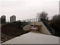
7
Underpass from Bridge House Meadows to Hornshay St
The railway is the London Overground between Queens Road Peckham and Surrey Quays.
Image: © Robert Eva
Taken: 4 Jan 2020
0.06 miles
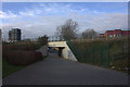
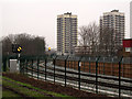
8
Hornshay Street subway
A new subway under the railway embankment links Hornshay Street to the west with Bridge House Meadows to the east.
The tower blocks in the distance are (I think) Grasmere Point Image and Ambleside Point.
Image: © Stephen Craven
Taken: 18 Jan 2013
0.07 miles
9
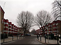
Lovelinch Close
Looking north from Hornshay Street, with three-storey housing blocks either side.
Image: © Stephen Craven
Taken: 18 Jan 2013
0.07 miles
10
Signals on the Peckham link line
The four aspect signal (at double yellow in this view) protects the junction of the link line from Surrey Quays with the South London line through Peckham. because of the curving track, there is an advance repeater, which is showing a diagonal (caution) aspect.
Image: © Stephen Craven
Taken: 18 Jan 2013
0.08 miles