IMAGES TAKEN NEAR TO
Sharratt Street, LONDON, SE15 1EZ
Introduction
This page details the photographs taken nearby to Sharratt Street, SE15 1EZ by members of the Geograph project.
The Geograph project started in 2005 with the aim of publishing, organising and preserving representative images for every square kilometre of Great Britain, Ireland and the Isle of Man.

There are currently over 7.5m images from over14,400 individuals and you can help contribute to the project by visiting https://www.geograph.org.uk
Image Map
Images are licensed for reuse under creativecommons.org/licenses/by-sa/2.0
Notes
- Clicking on the map will re-center to the selected point.
- The higher the marker number, the further away the image location is from the centre of the postcode.
Image Listing (82 Images Found)
Images are licensed for reuse under creativecommons.org/licenses/by-sa/2.0
Image
Details
Distance
1
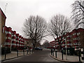
Lovelinch Close
Looking north from Hornshay Street, with three-storey housing blocks either side.
Image: © Stephen Craven
Taken: 18 Jan 2013
0.06 miles
2
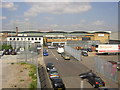
Ilderton Road industrial area, from the train
Ilderton Road is a largely industrial area, developed as such by the former Greater London Council.
Image: © Christopher Hilton
Taken: 2 Jun 2011
0.07 miles
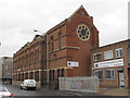
3
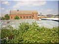
Ilderton Road: Christ the King Chapel, from the train
Ilderton Road is a largely industrial area, developed as such by the former Greater London Council. The chapel here is a Pentecostal one.
Image: © Christopher Hilton
Taken: 2 Jun 2011
0.09 miles
4
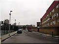
Hornshay Street
Saltwood House on the right; sports facilities (basketball and football) on the left.
Image: © Stephen Craven
Taken: 18 Jan 2013
0.09 miles
5
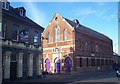
Christ the King Chapel, Bermondsey
Baptist Chapel on the junction of Ilderton Road (on the right) and Manor Grove (on the left).
Image: © David Anstiss
Taken: 27 Nov 2009
0.09 miles
6
Signals on the Peckham link line
The four aspect signal (at double yellow in this view) protects the junction of the link line from Surrey Quays with the South London line through Peckham. because of the curving track, there is an advance repeater, which is showing a diagonal (caution) aspect.
Image: © Stephen Craven
Taken: 18 Jan 2013
0.09 miles
7
Christ the King Chapel, Bermondsey
Image: © Richard Rogerson
Taken: 24 May 2013
0.09 miles
8
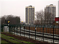
Hornshay Street subway
A new subway under the railway embankment links Hornshay Street to the west with Bridge House Meadows to the east.
The tower blocks in the distance are (I think) Grasmere Point Image and Ambleside Point.
Image: © Stephen Craven
Taken: 18 Jan 2013
0.09 miles
9
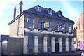
The Barnaby Public House, Bermondsey
Closed pub on Ilderton Road, beside Manor Grove. Was once also the Canterbury Tavern.
See http://www.london-se1.co.uk/forum/read/2/109041 for a chat-forum on the pub.
Image: © David Anstiss
Taken: 27 Nov 2009
0.10 miles
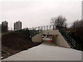
10
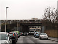
Hornshay Street railway bridge
The bridge, with a height limit of 4.5 metres, carries the South London Line (between South Bermondsey and Queens Road stations).
Image: © Stephen Craven
Taken: 18 Jan 2013
0.10 miles