IMAGES TAKEN NEAR TO
Juno Way, LONDON, SE14 5FZ
Introduction
This page details the photographs taken nearby to Juno Way, SE14 5FZ by members of the Geograph project.
The Geograph project started in 2005 with the aim of publishing, organising and preserving representative images for every square kilometre of Great Britain, Ireland and the Isle of Man.

There are currently over 7.5m images from over14,400 individuals and you can help contribute to the project by visiting https://www.geograph.org.uk
Image Map
Images are licensed for reuse under creativecommons.org/licenses/by-sa/2.0
Notes
- Clicking on the map will re-center to the selected point.
- The higher the marker number, the further away the image location is from the centre of the postcode.
Image Listing (195 Images Found)
Images are licensed for reuse under creativecommons.org/licenses/by-sa/2.0
Image
Details
Distance
1
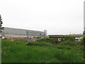
Demolition site, Juno Way (1)
Unfortunately I had not photographed the industrial units on this side of Juno Way before I realised they were being demolished. The redevelopment of the site, still industrial, is to be known as "Lewisham Trade Park". The large building in the background, now revealed more clearly, is the London Overground Depot at New Cross Gate.
Image: © Stephen Craven
Taken: 25 Apr 2014
0.01 miles
2
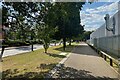
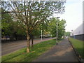
Path, Surrey Canal Road
Looking west. Technically a footway but apparently a magnet for cyclists, making it hazardous for anyone on foot. The road is lined with business and industrial premises.
Photo number 7878640.
Image: © Robin Stott
Taken: 29 Aug 2024
0.03 miles
3
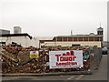
Demolition site, Juno Way (2)
Unfortunately I had not photographed the industrial units on this side of Juno Way before I realised they were being demolished. The tower in the background, now revealed more clearly, bears the name "Elizabeth Industrial Estate". The redevelopment of the site, still industrial, is to be known as "Lewisham Trade Park".
Image: © Stephen Craven
Taken: 25 Apr 2014
0.03 miles
4
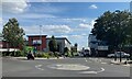
Mercury Way, New Cross Gate
Mercury Way runs south off Surrey Canal Road, serving an extensive business and industrial zone. The green sign, left, is headed Elizabeth and Juno Way Industrial Estate.
Photo number 7878654.
Image: © Robin Stott
Taken: 29 Aug 2024
0.03 miles
5
Surrey Canal Road
Work started on the Surrey Canal in 1801, which it was intended should run from Rotherhithe to Kingston, but by 1807 it had only reached New Cross and then only as access to the Croydon Canal. It eventually reached Camberwell in 1811 and Peckham in 1826. Its main traffic was to take timber from the Surrey Docks inland to saw mills, built alongside the canal. The original section ran here along what is now Surrey Canal Road. The Surrey Canal was eventually filled in during 1972 and here at Surrey Canal Road the canal bed was used for the road, whilst the north bank and towpath provide the walkway seen here.
Image: © Marathon
Taken: 19 Apr 2011
0.03 miles
6
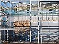
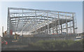
Insulation to new steel clad building
This new building (probably to be a warehouse), shown in an earlier stage of construction in Image six weeks earlier, was being clad in double skin steel with thick insulation between.
Image: © Stephen Craven
Taken: 30 Jun 2015
0.04 miles
7
Juno Enterprise Centre
Part of an industrial estate to the south of Surrey Canal Road.
Image: © Stephen Craven
Taken: 21 May 2011
0.05 miles
8
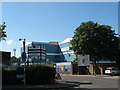
London Overground depot - complete
A view from the corner of Surrey Canal Road and Trundleys Road. For construction of the new depot, see Image and Image
Image: © Stephen Craven
Taken: 18 Apr 2009
0.05 miles
9
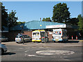
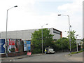
J's cafe
A cafe on Surrey Canal Road, serving the employees and visitors of the adjacent industrial estates. Two ice-cream vans were parked outside on this Saturday morning.
The view also shows a telephone box and the mini-roundabout at the junction with Landemann Way (to the right).
Image: © Stephen Craven
Taken: 21 May 2011
0.06 miles
10
New railway depot for London Overground
The new depot is being built alongside Image and will house trains on the London Overground line which will replace the closed East London tube line.
Image: © Stephen Craven
Taken: 14 Apr 2008
0.06 miles