IMAGES TAKEN NEAR TO
Loampit Hill, LONDON, SE13 7ST
Introduction
This page details the photographs taken nearby to Loampit Hill, SE13 7ST by members of the Geograph project.
The Geograph project started in 2005 with the aim of publishing, organising and preserving representative images for every square kilometre of Great Britain, Ireland and the Isle of Man.

There are currently over 7.5m images from over14,400 individuals and you can help contribute to the project by visiting https://www.geograph.org.uk
Image Map
Images are licensed for reuse under creativecommons.org/licenses/by-sa/2.0
Notes
- Clicking on the map will re-center to the selected point.
- The higher the marker number, the further away the image location is from the centre of the postcode.
Image Listing (224 Images Found)
Images are licensed for reuse under creativecommons.org/licenses/by-sa/2.0
Image
Details
Distance
1

St Johns, Lewisham: rail-over-rail bridge being removed
View SW from Brookmill Road, 3½ days after the dreadful collision at 18.20 on 4 December 1957 in dense fog, when the 16.56 Cannon Street to Ramsgate express (steam-hauled, by Light Pacific No. 34066 'Spitfire') had collided with the preceding electric 17.18 Charing Cross to Hayes with such force that the massive bridge girder carrying the Nunhead - Lewisham line was brought down onto the leading coaches of the express. In this picture and Image the damaged bridge was being cut up to clear the lines and allow the removal of the parts of the train caught under the collapsed bridge. For details, see 'St Johns, Lewisham - 50 years on: restoring the traffic', by Peter Tatlow: Oakwood Press 2007 (ISBN 978 085361 669 6), where the author points out that the temporary bridge that replaced the one in the photograph has continued in service, with some modifications, until at least 2007!
Image: © Ben Brooksbank
Taken: 8 Dec 1957
0.04 miles
3

Restoration of rail-over-rail bridge after accident at St Johns
Another view, see Image
Image: © Ben Brooksbank
Taken: 8 Dec 1957
0.05 miles
4
Squeezing them in on Elswick Road
A curious arrangement of houses at the acute corner on the road. It is as if the Victorian developer had built the rows of houses from left and right up to the corner, then suddenly realized he could fit three more into the awkward corner space of his plot via a short blind alley. The houses, according to maps, are all of very similar age. If he had thought ahead, he could have left one of the houses out on left or right, and continued the other row with four extra houses. No more houses, but a simpler arrangement.
Image: © Robin Webster
Taken: 1 Oct 2011
0.05 miles

6

Site of St Johns Accident, from Brookmill Road
Image: © Ben Brooksbank
Taken: 8 Dec 1957
0.05 miles

8
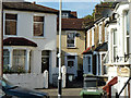
House in Loampit Hill SE4
At the junction with Somerset Gardens SE13
Image: © Robin Sones
Taken: 8 Apr 2010
0.07 miles
9
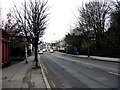
Brookmill Road
Looking south-east. Brookmill Road is not overly busy, but is in fact part of an A road, the A2210.
Image: © Dr Neil Clifton
Taken: 20 Jan 2010
0.07 miles
10
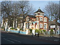
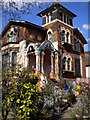
Loampit Hill, SE13 (2)
This picture was taken at the junction of Somerset Gardens. The house on the corner has a colour scheme that is somewhat striking. It has painted like this for at least 20 years.
Image: © Danny P Robinson
Taken: 14 Jan 2007
0.07 miles