St Johns, Lewisham: rail-over-rail bridge being removed
Introduction
The photograph on this page of St Johns, Lewisham: rail-over-rail bridge being removed by Ben Brooksbank as part of the Geograph project.
The Geograph project started in 2005 with the aim of publishing, organising and preserving representative images for every square kilometre of Great Britain, Ireland and the Isle of Man.

There are currently over 7.5m images from over 14,400 individuals and you can help contribute to the project by visiting https://www.geograph.org.uk
St Johns, Lewisham: rail-over-rail bridge being removed
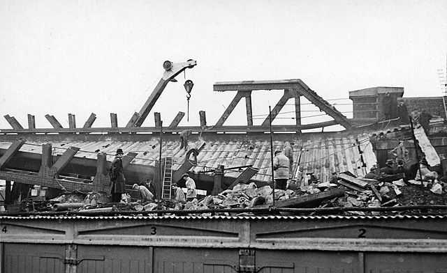
Image: © Ben Brooksbank Taken: 8 Dec 1957
View SW from Brookmill Road, 3½ days after the dreadful collision at 18.20 on 4 December 1957 in dense fog, when the 16.56 Cannon Street to Ramsgate express (steam-hauled, by Light Pacific No. 34066 'Spitfire') had collided with the preceding electric 17.18 Charing Cross to Hayes with such force that the massive bridge girder carrying the Nunhead - Lewisham line was brought down onto the leading coaches of the express. In this picture and Image the damaged bridge was being cut up to clear the lines and allow the removal of the parts of the train caught under the collapsed bridge. For details, see 'St Johns, Lewisham - 50 years on: restoring the traffic', by Peter Tatlow: Oakwood Press 2007 (ISBN 978 085361 669 6), where the author points out that the temporary bridge that replaced the one in the photograph has continued in service, with some modifications, until at least 2007!
Images are licensed for reuse under creativecommons.org/licenses/by-sa/2.0
Image Location
Latitude
51.46749
Longitude
-0.019417