IMAGES TAKEN NEAR TO
Princes Rise, LONDON, SE13 7PW
Introduction
This page details the photographs taken nearby to Princes Rise, SE13 7PW by members of the Geograph project.
The Geograph project started in 2005 with the aim of publishing, organising and preserving representative images for every square kilometre of Great Britain, Ireland and the Isle of Man.

There are currently over 7.5m images from over14,400 individuals and you can help contribute to the project by visiting https://www.geograph.org.uk
Image Map
Images are licensed for reuse under creativecommons.org/licenses/by-sa/2.0
Notes
- Clicking on the map will re-center to the selected point.
- The higher the marker number, the further away the image location is from the centre of the postcode.
Image Listing (90 Images Found)
Images are licensed for reuse under creativecommons.org/licenses/by-sa/2.0
Image
Details
Distance
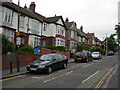
1
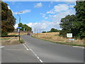
Lewisham Hill (2)
Lewisham Hill at the junction of St Austell Road and Wat Tyler Road. This is a scenic route from Lewisham to Greenwich on foot or by cycle.
Image: © Danny P Robinson
Taken: 13 Aug 2006
0.07 miles
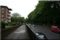
2
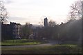
Lewisham Hill
This road leads from Blackheath Common down to central Lewisham. St. Austell's Road junction is on the left.
Image: © David Anstiss
Taken: 27 Nov 2009
0.08 miles
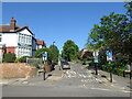
3
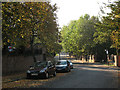
Dartmouth Row, Lewisham
The road is named after the Earls of Dartmouth who own (or owned) most of the land around here. The dead-end road on the right is Morden Hill; beyond that junction the through road becomes Lewisham Hill and leads down into Lewisham town centre.
Image: © Stephen Craven
Taken: 11 Oct 2010
0.11 miles
4
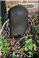
Old Boundary Marker on Lewisham Hill, London SE10
London County Council parks boundary marker on the east side of Lewisham Hill SE10, against a south facing brick wall facing onto Blackheath. These posts mark the ownership of parks and open spaces – see http://www.metadyne.co.uk/n-PropertyAndOtherMarks.html#lcc.
Milestone Society National ID: KE_LCC07em
Image: © J Dunford
Taken: 1 Nov 2021
0.11 miles
5

The Sydney Arms
It was not clear whether this pub on Lewisham Road was actually closed, but it had a "to let" sign and graffiti on it saying "bring back the Sydney Arms as a proper pub".
Image: © Stephen Craven
Taken: 9 Jun 2012
0.12 miles
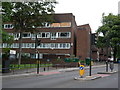
7
Morden Hill, Lewisham
Morden Hill is a residential road in Lewisham, in south east London.
Road signs indicate that the road is a "no through road" for motor vehicles, but is open to cyclists.
Image: © Malc McDonald
Taken: 8 May 2022
0.12 miles
8
Lewisham: Lewisham Hill
Unusually, this road has a raised and fenced-off footway on both sides of the road, suggesting that in former times the road surface itself has been lowered.
Image: © Dr Neil Clifton
Taken: 16 Jun 2012
0.12 miles
9
Orchard Estate, Lewisham (1)
Lewisham Road, near the junction with Conington Road.
Image: © Danny P Robinson
Taken: 17 May 2007
0.12 miles
10
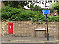
Victorian Postbox, Dartmouth Row
For a context see Image
Image: © Stephen Craven
Taken: 9 Jun 2012
0.13 miles