IMAGES TAKEN NEAR TO
Oppenheim Road, LONDON, SE13 7PT
Introduction
This page details the photographs taken nearby to Oppenheim Road, SE13 7PT by members of the Geograph project.
The Geograph project started in 2005 with the aim of publishing, organising and preserving representative images for every square kilometre of Great Britain, Ireland and the Isle of Man.

There are currently over 7.5m images from over14,400 individuals and you can help contribute to the project by visiting https://www.geograph.org.uk
Image Map
Images are licensed for reuse under creativecommons.org/licenses/by-sa/2.0
Notes
- Clicking on the map will re-center to the selected point.
- The higher the marker number, the further away the image location is from the centre of the postcode.
Image Listing (52 Images Found)
Images are licensed for reuse under creativecommons.org/licenses/by-sa/2.0
Image
Details
Distance
1
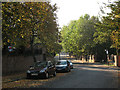
Dartmouth Row, Lewisham
The road is named after the Earls of Dartmouth who own (or owned) most of the land around here. The dead-end road on the right is Morden Hill; beyond that junction the through road becomes Lewisham Hill and leads down into Lewisham town centre.
Image: © Stephen Craven
Taken: 11 Oct 2010
0.08 miles
2
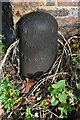
Old Boundary Marker on Lewisham Hill, London SE10
London County Council parks boundary marker on the east side of Lewisham Hill SE10, against a south facing brick wall facing onto Blackheath. These posts mark the ownership of parks and open spaces – see http://www.metadyne.co.uk/n-PropertyAndOtherMarks.html#lcc.
Milestone Society National ID: KE_LCC07em
Image: © J Dunford
Taken: 1 Nov 2021
0.08 miles
3
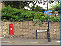
Victorian Postbox, Dartmouth Row
For a context see Image
Image: © Stephen Craven
Taken: 9 Jun 2012
0.08 miles
4
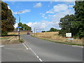
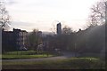
Lewisham Hill (2)
Lewisham Hill at the junction of St Austell Road and Wat Tyler Road. This is a scenic route from Lewisham to Greenwich on foot or by cycle.
Image: © Danny P Robinson
Taken: 13 Aug 2006
0.09 miles
5

Dartmouth House, Dartmouth Row, Blackheath
This 18th century house, now divided into apartments, is listed grade 2 (list entry number 1080040).
It appears to have had several different names: originally it was Dartmouth House, the London home of the Earl of that ilk. But the list description calls it "Southwark Diocesan House" as it was at one time owned by the Church of England (but a local vicar tells me they sold it in the 1970s). It was also known as the "Greyladies College for Women Workers", in institution founded in 1893, by Bishop Yeatman of Rochester and occupying this site from 1907, at which time a chapel was added. The Greyladies were "a society of ladies living together for the purpose of helping in the work of the Church of England under the incumbents of the diocese" at a time when of course they could not be priests themselves. Source: http://chestofbooks.com/food/household/Woman-Encyclopaedia-1/Religion-The-Greyladies-College-For-Women-Workers.html#.VaBAVl9Viko
Image: © Stephen Craven
Taken: 10 Jul 2015
0.10 miles
6
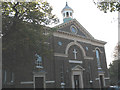
Church of the Ascension, Blackheath
This Anglican parish church on Dartmouth Row is grade 2* listed. It was originally a chapel founded in 1695, but the west end seen here dates from 1834 and is therefore classed as late Georgian. See the interior photo Image] for more history.
Image: © Stephen Craven
Taken: 11 Oct 2010
0.10 miles
7
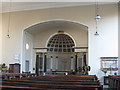
Interior of the Ascension church
The parish church of the Ascension was originally a chapel founded in 1695. Only the apse (semicircular sanctuary as shown in the photo) remains of this original building. The rest of the church was rebuilt by Lord Dartmouth in 1834. It was made a parish church in 1883; the pews date from that time. The church was restored after the Second World War with the north and south galleries being removed and the west gallery cut back.
Image: © Stephen Craven
Taken: 11 Oct 2010
0.11 miles
8
Greyladies Gardens, Blackheath
The name refers to the 1970s buildings seen within the walled compound marking the boundary of the original Dartmouth House estate. For an explanation of the name, see Image
Image: © Stephen Craven
Taken: 10 Jul 2015
0.11 miles
9
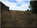
Path towards Blackheath
An unofficial path or "desire line" leading from Dartmouth Row up onto the heath itself.
Image: © Stephen Craven
Taken: 10 Jul 2015
0.11 miles
10
Lewisham Hill
This road leads from Blackheath Common down to central Lewisham. St. Austell's Road junction is on the left.
Image: © David Anstiss
Taken: 27 Nov 2009
0.11 miles