IMAGES TAKEN NEAR TO
Eliot Park, LONDON, SE13 7PJ
Introduction
This page details the photographs taken nearby to Eliot Park, SE13 7PJ by members of the Geograph project.
The Geograph project started in 2005 with the aim of publishing, organising and preserving representative images for every square kilometre of Great Britain, Ireland and the Isle of Man.

There are currently over 7.5m images from over14,400 individuals and you can help contribute to the project by visiting https://www.geograph.org.uk
Image Map
Images are licensed for reuse under creativecommons.org/licenses/by-sa/2.0
Notes
- Clicking on the map will re-center to the selected point.
- The higher the marker number, the further away the image location is from the centre of the postcode.
Image Listing (98 Images Found)
Images are licensed for reuse under creativecommons.org/licenses/by-sa/2.0
Image
Details
Distance
1
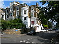
Lewisham Hill (1)
Lewisham Hill at the junction of Eliot Hill. This would once have been a magnificent house as a single unit but it is now converted into flats (look at the entryphone / doorbell). Nowadays it is rarely practical or affordable for one family to exclusively occupy large old houses such as this.
Image: © Danny P Robinson
Taken: 13 Aug 2006
0.04 miles
3
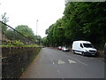
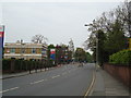
Lewisham: Lewisham Hill
Unusually, this road has a raised and fenced-off footway on both sides of the road, suggesting that in former times the road surface itself has been lowered.
Image: © Dr Neil Clifton
Taken: 16 Jun 2012
0.08 miles
4
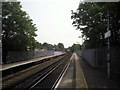
Lewisham station
The original part of Lewisham station opened in 1849, on the North Kent Line which by-passed Greenwich because the Royal Observatory did not want their sensitive instruments disturbed by trains. This view looks along that original line towards Blackheath. A Networker train is just leaving on its way to Blackheath.
Image: © Marathon
Taken: 6 May 2011
0.12 miles
5
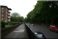
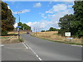
Lewisham Hill
This road leads from Blackheath Common down to central Lewisham. St. Austell's Road junction is on the left.
Image: © David Anstiss
Taken: 27 Nov 2009
0.12 miles
7
Lewisham Hill (2)
Lewisham Hill at the junction of St Austell Road and Wat Tyler Road. This is a scenic route from Lewisham to Greenwich on foot or by cycle.
Image: © Danny P Robinson
Taken: 13 Aug 2006
0.14 miles
8
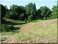
Eliot Pits, Blackheath
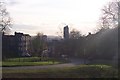
Blackheath was once extensively quarried for gravel, sand and chalk, and the pits remained open for many years. During the 1870s, the sharp sides of some of the gravel pits were eased to make them less dangerous. Many of the pits were filled in with bomb rubble after the Second World War, except for one or two around the edge of the Heath. Eliot Pits was possibly left because the land slopes away steeply from the edge of the Heath anyway.
Image: © Marathon
Taken: 31 May 2011
0.15 miles

10
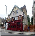
The Anchor, Lewisham
On Lewisham Road.
See Image] for sign.
Image: © JThomas
Taken: 24 Jun 2022
0.15 miles