IMAGES TAKEN NEAR TO
Brookbank Road, LONDON, SE13 7BX
Introduction
This page details the photographs taken nearby to Brookbank Road, SE13 7BX by members of the Geograph project.
The Geograph project started in 2005 with the aim of publishing, organising and preserving representative images for every square kilometre of Great Britain, Ireland and the Isle of Man.

There are currently over 7.5m images from over14,400 individuals and you can help contribute to the project by visiting https://www.geograph.org.uk
Image Map
Images are licensed for reuse under creativecommons.org/licenses/by-sa/2.0
Notes
- Clicking on the map will re-center to the selected point.
- The higher the marker number, the further away the image location is from the centre of the postcode.
Image Listing (98 Images Found)
Images are licensed for reuse under creativecommons.org/licenses/by-sa/2.0
Image
Details
Distance
1
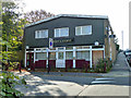
The Crown and Anchor, SE13 (closed)
A curiously bland modern building, that was later demolished and replaced with flats.
Image: © Robin Webster
Taken: 1 Oct 2011
0.04 miles
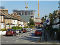
3
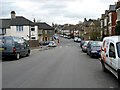
Shell Road, Lewisham
Looking towards mini-roundabout at Brookbank Road.
Image: © Eric Lyus
Taken: 16 Feb 2012
0.08 miles
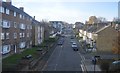
5
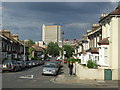
Ellerdale Street, Lewisham
Ellerdale Street is a residential street in Lewisham, South East London. The tall building in the background is an office block in Lewisham town centre.
Image: © Malc McDonald
Taken: 29 Jun 2011
0.12 miles
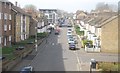
6
Brookbank Road, SE13
Looking down the road towards the railway bridge, at which the road is permanently blocked as the area beyond is being redeveloped.
Image: © Robin Webster
Taken: 1 Oct 2011
0.12 miles
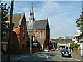
7
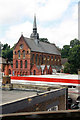
Bibleway Tabernacle Church, Algernon Road
Image: © John Salmon
Taken: 2 Jul 2010
0.12 miles
9

Vacant land off Loampit Vale, from the railway
Beyond the flats is Algernon Road Baptist Church. Creeping in on the extreme right is a tiny corner of the Esso filling station at the junction of Algernon Road and Loampit Vale.
Image: © Christopher Hilton
Taken: 9 Jun 2014
0.12 miles
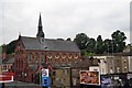
10
The Tabernacle, Algernon Road
A Christian place of worship.
Image: © Robin Webster
Taken: 1 Oct 2011
0.13 miles