IMAGES TAKEN NEAR TO
Kemps Gardens, LONDON, SE13 6PP
Introduction
This page details the photographs taken nearby to Kemps Gardens, SE13 6PP by members of the Geograph project.
The Geograph project started in 2005 with the aim of publishing, organising and preserving representative images for every square kilometre of Great Britain, Ireland and the Isle of Man.

There are currently over 7.5m images from over14,400 individuals and you can help contribute to the project by visiting https://www.geograph.org.uk
Image Map
Images are licensed for reuse under creativecommons.org/licenses/by-sa/2.0
Notes
- Clicking on the map will re-center to the selected point.
- The higher the marker number, the further away the image location is from the centre of the postcode.
Image Listing (26 Images Found)
Images are licensed for reuse under creativecommons.org/licenses/by-sa/2.0
Image
Details
Distance
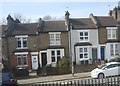
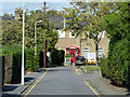
1
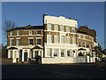
The Spotted Cow (closed)
A closed pub on the corner of Thornford Road (foreground) and Hither Green Lane.
Image: © Stephen Craven
Taken: 29 Mar 2011
0.03 miles
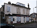
2
Nobody lives here anymore
A well shuttered empty house on Romborough Way.
Image: © Robin Webster
Taken: 1 Oct 2011
0.14 miles
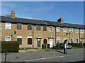
3

Houses on Campshill Road, Lewisham
The spire of the United Reformed Church is showing through the gap.
Image: © Robin Webster
Taken: 1 Oct 2011
0.14 miles
4
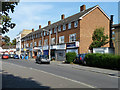
Shops on Campshill Road, Lewisham
These replaced a row of Victorian houses called Ladywell Park Terrace. There is a former pub of similar age, the Sir John Morden, at the far end. It closed around 2004.
Image: © Robin Webster
Taken: 1 Oct 2011
0.14 miles
5
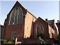
St. Swithun's Church, Hither Green
Large Grade II listed church on Hither Green Lane.
See http://www.britishlistedbuildings.co.uk/en-203304-church-of-st-swithun-lewisham for more details about the building.
See also Image
Image: © David Anstiss
Taken: 25 Sep 2011
0.16 miles
6
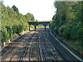
Main London - Dover line, east of Lewisham
Looking towards Dover from the Courthill Road bridge. The next bridge along is bollarded off to vehicles, except possibly two-wheelers.
Image: © Robin Webster
Taken: 1 Oct 2011
0.16 miles
7
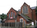
St Swithun's church and hall
The building in the foreground is the church hall (dating from 1884) and behind is the east end of the parish church (1893).
Image: © Stephen Craven
Taken: 13 Aug 2005
0.16 miles
8
Former pub, Courthill Road, SE13
The building in the centre of the photo used to be a pub called the Queen's Arms. It has now been converted into flats.
Image: © Malc McDonald
Taken: 19 Mar 2011
0.16 miles
9
Romborough Gardens
A quiet backwater in Lewisham.
Image: © Robin Webster
Taken: 1 Oct 2011
0.19 miles