IMAGES TAKEN NEAR TO
Station Road, LONDON, SE13 5FR
Introduction
This page details the photographs taken nearby to Station Road, SE13 5FR by members of the Geograph project.
The Geograph project started in 2005 with the aim of publishing, organising and preserving representative images for every square kilometre of Great Britain, Ireland and the Isle of Man.

There are currently over 7.5m images from over14,400 individuals and you can help contribute to the project by visiting https://www.geograph.org.uk
Image Map
Images are licensed for reuse under creativecommons.org/licenses/by-sa/2.0
Notes
- Clicking on the map will re-center to the selected point.
- The higher the marker number, the further away the image location is from the centre of the postcode.
Image Listing (247 Images Found)
Images are licensed for reuse under creativecommons.org/licenses/by-sa/2.0
Image
Details
Distance
1
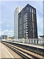
Lewisham station
Tower block alongside Lewisham station.
Image: © Alan Hughes
Taken: 11 Aug 2019
0.01 miles
2
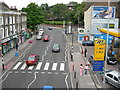
Lewisham Road SE13
Looking towards the junction of Lewisham Hill.
Image: © Danny P Robinson
Taken: 27 Jun 2006
0.01 miles
3
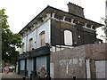
Pitchers Diner (closed)
I expect this building was once a conventional pub, more recently it was "Pitchers bar and diner" but closed in the recession of 2009 like many other eating and drinking places. It was demolished within 18 months - see Image for the space after redevelopment.
Image: © Stephen Craven
Taken: 10 Oct 2009
0.02 miles
5
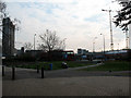
New open space in Lewisham
A small open space near the bus station, resulting from the demolition of the pub most recently known as Pitchers (see Image ).
Image: © Stephen Craven
Taken: 20 Mar 2011
0.02 miles
6
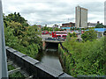
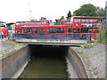
Ravensbourne River and bus station Lewisham, 2011
Now built on with flats. It looks like the Quaggy River comes in from the left just before the bridge.
Image: © Robin Webster
Taken: 25 Jun 2011
0.02 miles
7
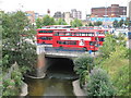
The confluence of the River Ravensbourne and the Quaggy River
Image: © Mike Quinn
Taken: 5 Aug 2009
0.02 miles
8
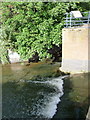
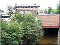
Lewisham: the Quaggy River?s journey?s end
Seen here coming towards us from behind a brick wall, the Quaggy River reaches the end of its journey through 8 miles or so of London's southeastern suburbs. It flows into the Ravensbourne River which has only travelled a couple of miles to this point and has only another couple to go before flowing into the Thames at Deptford.
Image: © Chris Downer
Taken: 4 Jun 2012
0.02 miles
9
The River Ravensbourne in Lewisham bus station (2)
Image: © Mike Quinn
Taken: 5 Aug 2009
0.02 miles
10
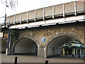
Railway arches at Lewisham station
These arches are part of the viaduct carrying platforms 3 and 4 of Lewisham railway station (the line to Blackheath and Bexley) over Lewisham Road.
Beyond the arches is a glimpse of Maggies restaurant - see Image
Image: © Stephen Craven
Taken: 20 Mar 2011
0.03 miles