IMAGES TAKEN NEAR TO
Jamaica Road, LONDON, SE1 2RN
Introduction
This page details the photographs taken nearby to Jamaica Road, SE1 2RN by members of the Geograph project.
The Geograph project started in 2005 with the aim of publishing, organising and preserving representative images for every square kilometre of Great Britain, Ireland and the Isle of Man.

There are currently over 7.5m images from over14,400 individuals and you can help contribute to the project by visiting https://www.geograph.org.uk
Image Map
Images are licensed for reuse under creativecommons.org/licenses/by-sa/2.0
Notes
- Clicking on the map will re-center to the selected point.
- The higher the marker number, the further away the image location is from the centre of the postcode.
Image Listing (488 Images Found)
Images are licensed for reuse under creativecommons.org/licenses/by-sa/2.0
Image
Details
Distance
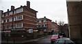
1
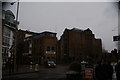
View of Kalmars and the block of flats and Coop on Tooley Street
Looking north-northeast.
Image: © Robert Lamb
Taken: 27 Jan 2019
0.02 miles
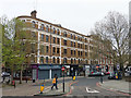
2
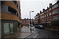
View down Sweeney Crescent from Jamaica Road
Looking south-southeast.
Image: © Robert Lamb
Taken: 27 Jan 2019
0.02 miles
3
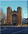
Roman Catholic Church of The Most Holy Trinity, Bermondsey
Grade II* listed: architect Harry Stuart Goodhart-Rendel. Description at this https://historicengland.org.uk/listing/the-list/list-entry/1376609.
Image: © Jim Osley
Taken: 5 Jan 2017
0.02 miles
5
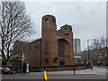
Holy Trinity Church, Dockhead, London SE1
Holy Trinity is a Roman Catholic Church behind St Saviour's Dock. The present polychromatic brick building designed by HS Goodhart-Rendel and completed in 1959 (the year of his death) has a hint of the Victorian architect William Butterfield. This is apt, as the building replaces an 1834 gothic church destroyed in the war along with the presbytery and a Pugin-designed convent.
This was the first Roman Catholic church since the Reformation to be built fronting a public highway. The main road once ran to the north of the church - hence today's strangely long bleak wall here. The very old days are recalled with a 12th-century stone found on the site of nearby Bermondsey Abbey.
Image: © Christine Matthews
Taken: 10 Mar 2016
0.02 miles
6
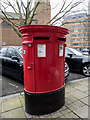
Queen Elizabeth II Double Pillar Box, Dockhead, London SE1
This double pillar box is opposite Holy Trinity Roman Catholic Church.
Image: © Christine Matthews
Taken: 10 Mar 2016
0.02 miles
7
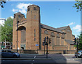
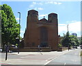
Most Holy Trinity, Jamaica Road
Rebuilt by H.S. Goodhart-Rendel in 1960 - although planning must have started earlier as he died in 1959 - after Kempthorne's 1830s original was destroyed by bombing. Probably fair to say that Goodhart-Rendel's interesting building owes little to its predecessor. Grade II* listed.
Image: © Stephen Richards
Taken: 27 May 2013
0.02 miles
8
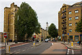
A200, Jamaica Road
Looking from the junction with Dockhead and Mill Street towards the traffic lights at the junction with Tooley Street. The embryonic Shard can be seen looming in the distance.
Image: © Martin Addison
Taken: 22 Oct 2010
0.03 miles
9
View of flats on the Arnold Estate from Jamaica Road
Looking south-southwest.
Image: © Robert Lamb
Taken: 27 Jan 2019
0.03 miles
10
Tower Bridge Buildings, Dockhead, SE1
A hopeful name, I have some doubt whether even the top floor can see much of the bridge. The flats are accessed from behind, Mill Street, and use that address.
Image: © Robin Webster
Taken: 6 Apr 2019
0.03 miles