IMAGES TAKEN NEAR TO
Mayeswood Road, LONDON, SE12 9RR
Introduction
This page details the photographs taken nearby to Mayeswood Road, SE12 9RR by members of the Geograph project.
The Geograph project started in 2005 with the aim of publishing, organising and preserving representative images for every square kilometre of Great Britain, Ireland and the Isle of Man.

There are currently over 7.5m images from over14,400 individuals and you can help contribute to the project by visiting https://www.geograph.org.uk
Image Map
Images are licensed for reuse under creativecommons.org/licenses/by-sa/2.0
Notes
- Clicking on the map will re-center to the selected point.
- The higher the marker number, the further away the image location is from the centre of the postcode.
Image Listing (94 Images Found)
Images are licensed for reuse under creativecommons.org/licenses/by-sa/2.0
Image
Details
Distance
1
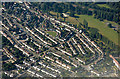
Grove Park from the air
Chinbrook Meadows park is to the top right.
Image: © Thomas Nugent
Taken: 26 Aug 2019
0.06 miles
3
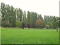
Chinbrook Meadows
The park takes its name from the stream commonly known as the Quaggy River but sometimes referred to as the Kyd Brook or Chin Brook. In the 1960s the Quaggy River within Chinbrook Meadows and other parks was channelled into long straight concrete culverts to alleviate flooding and was closed off behind tall hedges and iron fences; this cut the park in two with the larger part to the east of the river. In the early 2000s however the concrete channel with its fences and hedges was demolished and river was remodelled to give a natural, meandering appearance with a small flood plain; this was to encourage wild plants and animals back to the area and to be more pleasant and attractive for the public. The regeneration was completed on 1 October 2002 and cost a reported £1.1million. For more info see the Wiki entry http://en.wikipedia.org/wiki/Chinbrook_Meadows and the official Lewisham site http://www.lewisham.gov.uk/LeisureAndCulture/ParksAndRecreation/LocalParks/ChinbrookMeadows.htm.
Image: © Mike Quinn
Taken: 28 Sep 2010
0.09 miles
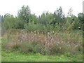
5

Chinbrook Meadows
Here the Quaggy emerges from being little more than a drain into a proper watercourse in a respectably green environment. See Image for more information. The path carries the Green Chain Walk along the valley.
Image: © Derek Harper
Taken: 9 May 2013
0.10 miles
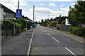
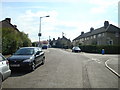
8
Grove Park Road, Mottingham SE12
Looking northeast. Marvels Lane leads left and right from this crossroads; the B226 Grove Park Road is ahead, with B226 Chinbrook Road behind the camera and to the left.
Image: © Philip Talmage
Taken: 4 Nov 2005
0.11 miles
9
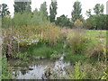
Pond by the Quaggy River at the northwest corner of Chinbrook Meadows
There IS water in the pond - see Image
Image: © Mike Quinn
Taken: 28 Sep 2010
0.11 miles
10
Pond by the Quaggy River at the northwest corner of Chinbrook Meadows (2)
Image: © Mike Quinn
Taken: 28 Sep 2010
0.12 miles