IMAGES TAKEN NEAR TO
Newstead Road, LONDON, SE12 0SZ
Introduction
This page details the photographs taken nearby to Newstead Road, SE12 0SZ by members of the Geograph project.
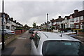
The Geograph project started in 2005 with the aim of publishing, organising and preserving representative images for every square kilometre of Great Britain, Ireland and the Isle of Man.

There are currently over 7.5m images from over14,400 individuals and you can help contribute to the project by visiting https://www.geograph.org.uk
Image Map
Images are licensed for reuse under creativecommons.org/licenses/by-sa/2.0
Notes
- Clicking on the map will re-center to the selected point.
- The higher the marker number, the further away the image location is from the centre of the postcode.
Image Listing (65 Images Found)
Images are licensed for reuse under creativecommons.org/licenses/by-sa/2.0
Image
Details
Distance
1
A loft conversion on Dallinger Road
Currently quite a popular home improvement in the London area.
Image: © Bill Boaden
Taken: 11 Oct 2014
0.06 miles
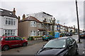
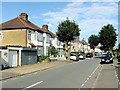
4
Manor Lane, Hither Green
Viewed in a rain shower at its junction with Dallinger Road. It is a large residential area.
Image: © Bill Boaden
Taken: 11 Oct 2014
0.10 miles
6
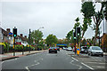
Pedestrian lights, St. Mildreds Road
Looking west.
Image: © Robin Webster
Taken: 30 Oct 2011
0.14 miles
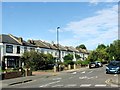
7
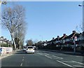
The South Circular Road, at Lee, SE12: St Mildred's Road
This stretch of the South Circular will be familiar to many people who (like myself) know little or nothing of the rest of the grid-square. The view is eastward, with the roof of St Mildred's Church visible in the distance. The plane trees gleam in the February sunshine.
Unlike the North Circular, which was largely purpose-built, engineering the South Circular amounted to little more than putting up signs to indicate the route - along existing roads. To road enthusiasts the South Circular is a bad joke - but the rest of us are probably grateful that swathes were not cut through South London's older local centres (Putney, say, or Battersea Rise). The price to be paid remains the presence of heavy through traffic in residential and shopping streets.
Image: © Stefan Czapski
Taken: 8 Feb 2011
0.14 miles
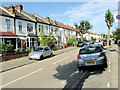
9
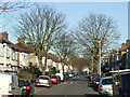
Milborough Crescent, Hither Green
The road isn't much like a crescent at this point, though it gets more so further on. The road is kept quiet as it is blocked off for traffic where it joins the South Circular Road. Viewed during a rain shower.
Image: © Bill Boaden
Taken: 11 Oct 2014
0.15 miles
10
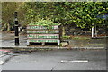
Roadside planter
At the end of Rayford Avenue, one of a matching pair on either side of the street. The wording reads: "ROAD OPEN To birds and bees And flowers, trees Slow drivers, please".
Image: © David Martin
Taken: 15 Feb 2022
0.15 miles