IMAGES TAKEN NEAR TO
Somertrees Avenue, LONDON, SE12 0BU
Introduction
This page details the photographs taken nearby to Somertrees Avenue, SE12 0BU by members of the Geograph project.
The Geograph project started in 2005 with the aim of publishing, organising and preserving representative images for every square kilometre of Great Britain, Ireland and the Isle of Man.

There are currently over 7.5m images from over14,400 individuals and you can help contribute to the project by visiting https://www.geograph.org.uk
Image Map
Images are licensed for reuse under creativecommons.org/licenses/by-sa/2.0
Notes
- Clicking on the map will re-center to the selected point.
- The higher the marker number, the further away the image location is from the centre of the postcode.
Image Listing (74 Images Found)
Images are licensed for reuse under creativecommons.org/licenses/by-sa/2.0
Image
Details
Distance
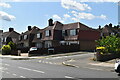
1
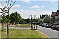
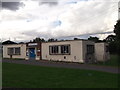
Grove Park Library
On the junction of Burnt Ash Hill and Marvels Lane.
In front is a footpath marker for the Green Chain Walk (long distance path), left to Grove Park Nature Reserve and right to College Meadow.
Image: © David Anstiss
Taken: 18 Sep 2011
0.03 miles
2
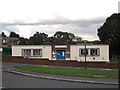
Grove Park Library
"Community library, staffed by volunteers, serving London’s Grove Park and surrounding areas. Featuring children’s library, free Internet-enabled PC access, wireless Internet, refreshments, recycling facilities. Books and laptops for sale at bargain prices." - Lewisham Local.
One of the Green Chain LDPs passes in front as shown by the prominent green guidepost.
Image: © Des Blenkinsopp
Taken: 6 Mar 2020
0.03 miles
3
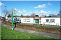
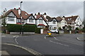
Bannatyne's Health Club, Grove Park SE12
At 35 Marvels Lane. Gym and pool.
Image: © Philip Talmage
Taken: 4 Nov 2005
0.04 miles
4
Grove Park Library (2)
On the junction of Burnt Ash Hill and Marvels Lane.
Image: © David Anstiss
Taken: 18 Sep 2011
0.04 miles
5
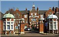
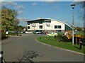
Former Grove Park Hospital
Grove Park Hospital was built to the designs of architect Thomas Dinwiddy as a workhouse for the poor of Greenwich in 1902. It was taken over by the Army in the First World War, and subsequently became a hospital. It is now a housing estate, although some of the hospital buildings have been preserved.
Image: © Jim Osley
Taken: 8 Mar 2011
0.04 miles
9
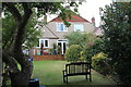
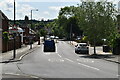
Rear of houses, Burnt Ash Lane, Lewisham
Two semi-detached 1930s suburban houses; there many houses of a similar design in the neighbourhood. In the left foreground is an apple tree.
Image: © M J Roscoe
Taken: 15 Oct 2016
0.10 miles