IMAGES TAKEN NEAR TO
Harleyford Road, LONDON, SE11 5AY
Introduction
This page details the photographs taken nearby to Harleyford Road, SE11 5AY by members of the Geograph project.
The Geograph project started in 2005 with the aim of publishing, organising and preserving representative images for every square kilometre of Great Britain, Ireland and the Isle of Man.

There are currently over 7.5m images from over14,400 individuals and you can help contribute to the project by visiting https://www.geograph.org.uk
Image Map
Images are licensed for reuse under creativecommons.org/licenses/by-sa/2.0
Notes
- Clicking on the map will re-center to the selected point.
- The higher the marker number, the further away the image location is from the centre of the postcode.
Image Listing (508 Images Found)
Images are licensed for reuse under creativecommons.org/licenses/by-sa/2.0
Image
Details
Distance
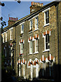
1
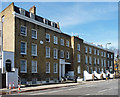
48-60 Harleyford Road
A plaque between the nearer pair is inscribed, "The Parade 1821", while the far group is named "Olum Terrace 1826" in the parapet. Grade II listed.
Image: © Stephen Richards
Taken: 21 Apr 2013
0.01 miles
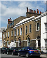
2
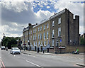
Georgian terraces on Harleyford Road
Clun Terrace, the nearer row, is dated 1826. The Parade, further along, has an 1821 datestone. This is the way from Vauxhall Station to The Oval Cricket Ground, one of whose floodlights shows above the trees on the extreme left of the picture.
Image: © John Sutton
Taken: 11 Jul 2023
0.01 miles
4
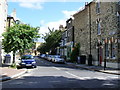
Vauxhall Grove
Picture taken from Bonnington Square
Image: © PAUL FARMER
Taken: 12 Jul 2009
0.04 miles
5
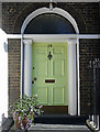
Detail of 19 Harleyford Road
Rather a grand doorcase, fluted columns and decorative fanlight, though the columns lack an entablature.
Image: © Stephen Richards
Taken: 21 Apr 2013
0.05 miles
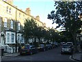
6
Bonnington Square, Vauxhall
Victorian houses in the north-eastern corner of the square.
Image: © Stephen McKay
Taken: 7 Nov 2008
0.05 miles
7
15-21 Harleyford Road
A little early C19th group, the arched ground floors a common motif of the time. Grade II listed.
Image: © Stephen Richards
Taken: 21 Apr 2013
0.05 miles
9
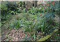
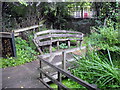
Harleyford Road Community Garden
In earlier times, a Georgian Terrace with long back gardens fronted onto Harleyford Road, but the majority of the houses were demolished in the early 1970s. The chance to site a community garden here was realised in 1984 by the Vauxhall Housing Co-operative, who formed the Harleyford Road Garden Association to carry out a feasibility study with the help of a small grant. Most of the land belonged to the Greater London Council and when this was abolished in 1986, lease negotiations became protracted. The land finally came under the Borough Council's Housing Department, from whom the Garden Association now hold a management lease.
Work on the design and layout of the site began in 1986 and Harleyford Road Community Garden was officially opened two years later. It had already started to be used by local people, however, such is the demand for open space in this very built-up part of the Borough.
Image: © Marathon
Taken: 26 Feb 2024
0.06 miles
10
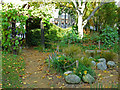
Bonnington Square Garden, Vauxhall
This small garden has been established on a Second World War bomb site; the story is told here: http://bonningtonsquaregarden.org.uk/index.html .
Image: © Stephen McKay
Taken: 7 Nov 2008
0.06 miles