IMAGES TAKEN NEAR TO
Old Pearson Street, LONDON, SE10 9LL
Introduction
This page details the photographs taken nearby to Old Pearson Street, SE10 9LL by members of the Geograph project.
The Geograph project started in 2005 with the aim of publishing, organising and preserving representative images for every square kilometre of Great Britain, Ireland and the Isle of Man.

There are currently over 7.5m images from over14,400 individuals and you can help contribute to the project by visiting https://www.geograph.org.uk
Image Map
Images are licensed for reuse under creativecommons.org/licenses/by-sa/2.0
Notes
- Clicking on the map will re-center to the selected point.
- The higher the marker number, the further away the image location is from the centre of the postcode.
Image Listing (605 Images Found)
Images are licensed for reuse under creativecommons.org/licenses/by-sa/2.0
Image
Details
Distance
1
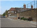
James Wolfe Primary School (2)
The eastern end of the school wall, at the start of Tarves Way. For more detail see Image
Image: © Stephen Craven
Taken: 24 Apr 2010
0.01 miles
2
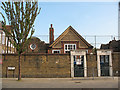
James Wolfe Primary School (3)
A pair of old gates in the brick wall around the school bearing the legend "girls" and "boys". This is opposite the end of Haddo Street. For more about the school see Image
Image: © Stephen Craven
Taken: 24 Apr 2010
0.03 miles
3
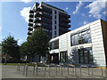
The 10 Centre, Greenwich
A community centre built as part of a large housing development Image
Image: © Stephen Craven
Taken: 21 Jun 2014
0.03 miles
4
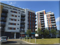
Flats on Tarves Way (2)
This was a large housing development completed a few years earlier.
Image: © Stephen Craven
Taken: 21 Jun 2014
0.04 miles
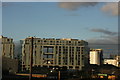
5
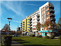
New housing on Tarves Way, Greenwich
A relatively recently-built apartment block on Tarves Way, in Greenwich.
Image: © Malc McDonald
Taken: 19 Nov 2017
0.04 miles
6
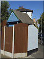
A thatched shed?
Glimpsed over the garden wall, what looks to be a garden shed with a thatched roof.
Image: © Stephen Craven
Taken: 21 Jun 2014
0.04 miles
7
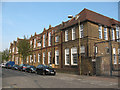
James Wolfe Primary School (1)
The school's main buildings are here on Randall Place. It was originally called Randall Place School but was renamed at some point after the general whose statue is found in the nearby park. The school has a special unit for deaf children.
Image: © Stephen Craven
Taken: 24 Apr 2010
0.05 miles
8
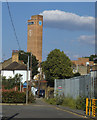
East end of Tarves Way
Unfortunately, when the large housing development here Image was completed a few years earlier, the local council neither obliged the developer to resurface the road that had been ruined by construction traffic, nor thought to upgrade this little pedestrian cut-through to Straightsmouth to a proper cycle link (it is used by cyclists but involves going up/down kerbs and coming to a blind corner).
Image: © Stephen Craven
Taken: 21 Jun 2014
0.05 miles
9

Spring blossom on Roan Street
White and pink blossom on trees on the corner of Roan Street and Haddon Street. The tall building in the distance is part of a recent development on Tarves Way.
Image: © Stephen Craven
Taken: 24 Apr 2010
0.05 miles