IMAGES TAKEN NEAR TO
Thornley Place, LONDON, SE10 9AF
Introduction
This page details the photographs taken nearby to Thornley Place, SE10 9AF by members of the Geograph project.
The Geograph project started in 2005 with the aim of publishing, organising and preserving representative images for every square kilometre of Great Britain, Ireland and the Isle of Man.

There are currently over 7.5m images from over14,400 individuals and you can help contribute to the project by visiting https://www.geograph.org.uk
Image Map
Images are licensed for reuse under creativecommons.org/licenses/by-sa/2.0
Notes
- Clicking on the map will re-center to the selected point.
- The higher the marker number, the further away the image location is from the centre of the postcode.
Image Listing (459 Images Found)
Images are licensed for reuse under creativecommons.org/licenses/by-sa/2.0
Image
Details
Distance
2
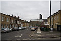
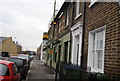
Caradoc Street
Viewed from the junction with Old Woolwich Road. It is part of a 20mph zone.
Image: © Stephen Craven
Taken: 6 Apr 2013
0.03 miles
3

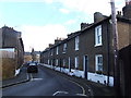
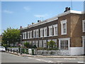
Hadrian Street
Most of the housing is terraced, late 19th century and typical of this area of East Greenwich. The two houses nearest the camera, named Cleveland Terrace, are more recent although the detailing including the sash windows and doorways has been made to match the older properties.
Image: © Stephen Craven
Taken: 6 Apr 2013
0.04 miles
5
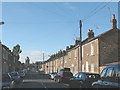
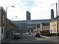
Hadrian Street, Greenwich
A view looking north along this street of traditional terraced housing, with in the distance the silos of the Amylum Refinery (now disused and shortly to be demolished).
Note the overhead telephone cables radiating from a timber pole - an increasingly rare sight as underground fibreoptic cables replace them.
Image: © Stephen Craven
Taken: 18 Jul 2010
0.04 miles
6
Terraced houses in Pelton Road Greenwich
Image: © Rod Allday
Taken: 27 Jun 2011
0.04 miles
7
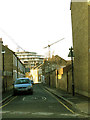
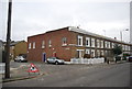
Banning Street, Greenwich
A mixture of older terraced housing and newer properties on this street, looking towards the disused power station Image
Image: © Stephen Craven
Taken: 14 Feb 2009
0.04 miles
8
Terraces, Pelton St
At the corner with Hadrian St.
Image: © N Chadwick
Taken: 17 Feb 2012
0.05 miles
10
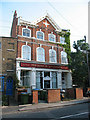
The Duke of Wellington (closed)
A former pub, now 120 Old Woolwich Road, Greenwich, that still bears its name. it is now residential accommodation.
Image: © Stephen Craven
Taken: 18 Jul 2010
0.05 miles