IMAGES TAKEN NEAR TO
Royal Hill, LONDON, SE10 8SS
Introduction
This page details the photographs taken nearby to Royal Hill, SE10 8SS by members of the Geograph project.
The Geograph project started in 2005 with the aim of publishing, organising and preserving representative images for every square kilometre of Great Britain, Ireland and the Isle of Man.

There are currently over 7.5m images from over14,400 individuals and you can help contribute to the project by visiting https://www.geograph.org.uk
Image Map
Images are licensed for reuse under creativecommons.org/licenses/by-sa/2.0
Notes
- Clicking on the map will re-center to the selected point.
- The higher the marker number, the further away the image location is from the centre of the postcode.
Image Listing (259 Images Found)
Images are licensed for reuse under creativecommons.org/licenses/by-sa/2.0
Image
Details
Distance
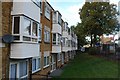
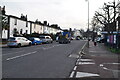
3
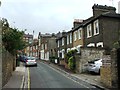
Housing on Greenwich South Street (Greenwich Ward 038E)
Image: © Emma R Smith
Taken: 14 Oct 2016
0.03 miles
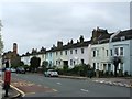
4
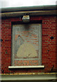
Faded mosaic pub sign, Greenwich
Once the Barley Mow, this former public house is now a restaurant.
Image: © Jim Osley
Taken: 11 Sep 2011
0.04 miles
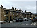
5
Housing on Greenwich South Street (Greenwich Ward 038E)
Image: © Emma R Smith
Taken: 14 Oct 2016
0.04 miles
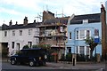
6
Housing on Greenwich South Street (Greenwich Ward 038E)
Image: © Emma R Smith
Taken: 14 Oct 2016
0.04 miles
8
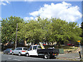
Bottom of Winforton Street
Trees on a small patch of undeveloped land at the junction with Blissett Street.
Image: © Stephen Craven
Taken: 21 Jun 2014
0.05 miles
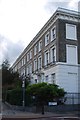
10
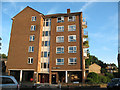
Darnell House
A five-storey apartment block on Royal Hill, Greenwich.
Image: © Stephen Craven
Taken: 9 Jul 2010
0.05 miles