IMAGES TAKEN NEAR TO
Westgrove Lane, LONDON, SE10 8QP
Introduction
This page details the photographs taken nearby to Westgrove Lane, SE10 8QP by members of the Geograph project.
The Geograph project started in 2005 with the aim of publishing, organising and preserving representative images for every square kilometre of Great Britain, Ireland and the Isle of Man.

There are currently over 7.5m images from over14,400 individuals and you can help contribute to the project by visiting https://www.geograph.org.uk
Image Map
Images are licensed for reuse under creativecommons.org/licenses/by-sa/2.0
Notes
- Clicking on the map will re-center to the selected point.
- The higher the marker number, the further away the image location is from the centre of the postcode.
Image Listing (153 Images Found)
Images are licensed for reuse under creativecommons.org/licenses/by-sa/2.0
Image
Details
Distance
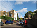
1
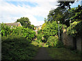
Diamond Terrace, central section
Diamond Terrace is marked on street maps at the same width as other local streets, but is definitely not navigable by motor vehicles, being in parts exceedingly narrow, overgrown, muddy, and with a 90-degree bend and steps. So I have categorised it as a path. Compare Image
Image: © Stephen Craven
Taken: 20 Jul 2012
0.05 miles
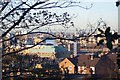
3
View of the O2 Dome from the Point
Looking Northwards from the viewpoint on Point Hill, near Blackheath Common. Also seen, is the Royal Naval College (smaller grey dome, on the right).
Image: © David Anstiss
Taken: 27 Nov 2009
0.06 miles
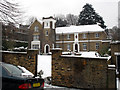
4
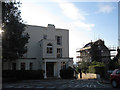
Grove House
This white house at the top of Westgrove Lane is shown on some large scale maps as a hotel but that appears not now to be the case. It is listed grade 2 under the name Grove House (list entry number 1212232).
Image: © Stephen Craven
Taken: 20 Jul 2012
0.06 miles
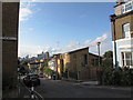
5
Point Hill, upwards
Looking up Point Hill from its junction with Maidenstone Hill. There is a postbox in the foreground. This is the steepest part of the hill with a gradient of approximately 13%. Compare Image
Image: © Stephen Craven
Taken: 20 Jul 2012
0.06 miles
6
Dominican Convent on Hyde Vale
A Catholic retreat house. The Sisters of the Sacred Heart of Jesus have been based here since 1951.
Image: © Stephen Craven
Taken: 5 Feb 2012
0.07 miles
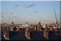
7
View of the River Thames, from the Point
Looking from the viewpoint on Point Hill, near Blackheath Common. Seen across the diverse range of roofs of London.
Image: © David Anstiss
Taken: 27 Nov 2009
0.07 miles
8
Point Hill, downwards
Looking down Point Hill from its junction with Maidenstone Hill (left). The distant view is of the skyscrapers of Docklands. Compare Image
Image: © Stephen Craven
Taken: 20 Jul 2012
0.08 miles
9
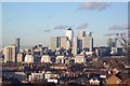
View Northwards from The Point
Looking from the viewpoint on Point Hill, near Blackheath Common. Looking at the Isle of Dogs. The tallest building is Canary Wharf. This and the rest of the other buildings are the new 'financial powerhouse' of London.
Image: © David Anstiss
Taken: 27 Nov 2009
0.08 miles
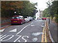
10
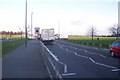
Start of the Rush Hour on Shooter's Hill Road
The A2 leads through Blackheath Common towards the A2 Dual carriageway heading south out of London. The Hyde Vale junction is on the left, and Wat Tyler Road is on the right. The rush hour on Fridays starts at 3pm on wards.
Image: © David Anstiss
Taken: 27 Nov 2009
0.08 miles