IMAGES TAKEN NEAR TO
Merryweather Place, LONDON, SE10 8BN
Introduction
This page details the photographs taken nearby to Merryweather Place, SE10 8BN by members of the Geograph project.
The Geograph project started in 2005 with the aim of publishing, organising and preserving representative images for every square kilometre of Great Britain, Ireland and the Isle of Man.

There are currently over 7.5m images from over14,400 individuals and you can help contribute to the project by visiting https://www.geograph.org.uk
Image Map
Images are licensed for reuse under creativecommons.org/licenses/by-sa/2.0
Notes
- Clicking on the map will re-center to the selected point.
- The higher the marker number, the further away the image location is from the centre of the postcode.
Image Listing (239 Images Found)
Images are licensed for reuse under creativecommons.org/licenses/by-sa/2.0
Image
Details
Distance
1
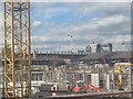
The rebuilding of West Greenwich
In the foreground, construction is being started of another residential development on Greenwich High Road, glimpsed through a hole in the hoardings around the site. In the middle distance, three cranes mark the site of another development on Creek Road. In between are the historic coal sheds Image, which being listed could not easily be removed for development. In the far distance are the landmark towers of Canary Wharf.
Image: © Stephen Craven
Taken: 29 Aug 2009
0.01 miles
2
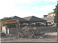
Historic coal sheds
These coal sheds are listed buildings (LBS ref. 398171/2 or Heritage asset numbers 1289021 & 1213549 as from 2011). They were built in 1865 to the designs of the famous architect Sir J W Bazalgette to store coal for the adjacent sewage pumping station (the building visible on the right of the picture). This view from Greenwich High Road has only been visible following demolition of a business centre for a redevelopment that was due to commence in 2011.
Image: © Stephen Craven
Taken: 21 Jul 2008
0.02 miles
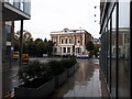
3
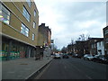
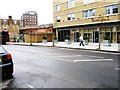
Greenwich High Road
The west side is the less posh part of Greenwich, that really begins in the centre and goes towards the south and east.
Image: © David Howard
Taken: 30 Dec 2012
0.03 miles
6
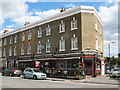
The Golden Chippy
The Golden Chippy / Golden Vineyard / Golden Cafe (presumably all under the same management) on the corner of Devonshire Drive (right) and Greenwich High Road (foreground).
Image: © Stephen Craven
Taken: 29 Aug 2009
0.04 miles
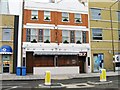
9
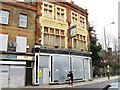
Royal Kent Dispensary (2)
For the history of this building see Image
Image: © Stephen Craven
Taken: 29 Aug 2009
0.05 miles
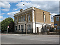
10
Royal Kent Instituted Dispensary
Grade II listed building, see https://historicengland.org.uk/listing/the-list/list-entry/1078995 and Image
Image: © Hugh Venables
Taken: 31 Oct 2021
0.05 miles