IMAGES TAKEN NEAR TO
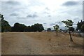
Allison Close, LONDON, SE10 8AZ
Introduction
This page details the photographs taken nearby to Allison Close, SE10 8AZ by members of the Geograph project.
The Geograph project started in 2005 with the aim of publishing, organising and preserving representative images for every square kilometre of Great Britain, Ireland and the Isle of Man.

There are currently over 7.5m images from over14,400 individuals and you can help contribute to the project by visiting https://www.geograph.org.uk
Image Map
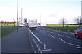
Images are licensed for reuse under creativecommons.org/licenses/by-sa/2.0
Notes
- Clicking on the map will re-center to the selected point.
- The higher the marker number, the further away the image location is from the centre of the postcode.
Image Listing (102 Images Found)
Images are licensed for reuse under creativecommons.org/licenses/by-sa/2.0
Image
Details
Distance
1
Path beside Blackheath Hill
Looking along a path over scorched grass during a prolonged dry spell.
Image: © DS Pugh
Taken: 2 Aug 2022
0.03 miles
2

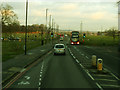
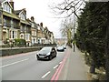
Bus stop at the top of Blackheath Hill
The stop is served by routes 386 and 53. A 53 is passing in the opposite direction.
Image: © Stephen Craven
Taken: 6 May 2013
0.03 miles
3
Top of Blackheath Hill
Taken from the bus stop in Image for a view looking down this part of the hill. Normally this road (the A2) is very busy, but tolerably quiet on a Sunday. See also Image
Image: © Stephen Craven
Taken: 18 Jan 2015
0.03 miles
4

Old Boundary Marker by the A2, Blackheath Hill SE10
Municipal Boundary Marker by the A2, in parish of Greenwich (Greenwich District), Blackheath Hill SE10, North West corner of Point Hill, next to Cypress trees.
Inscription taken from Historic England reads:-
: (illegible) yards from this point is the boundary of the Borough of Greenwich :
Grade II listed. List Entry Number: 1079051
https://historicengland.org.uk/listing/the-list/list-entry/1079051
Surveyed
Milestone Society National ID: KE_GREHB01pb.
Image: © Milestone Society
Taken: Unknown
0.04 miles
5
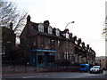
Lancelot Antiques
A shop at the top of Blackheath Hill.
Image: © Stephen Craven
Taken: 6 May 2013
0.04 miles
6
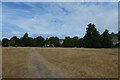
Path on Blackheath Hill
Looking along a path over scorched grass during a prolonged dry spell.
Image: © DS Pugh
Taken: 2 Aug 2022
0.05 miles
7
Start of the Rush Hour on Shooter's Hill Road
The A2 leads through Blackheath Common towards the A2 Dual carriageway heading south out of London. The Hyde Vale junction is on the left, and Wat Tyler Road is on the right. The rush hour on Fridays starts at 3pm on wards.
Image: © David Anstiss
Taken: 27 Nov 2009
0.05 miles
8
Blackheath Hill
Looking down the hill towards Deptford.
Image: © Mike Faherty
Taken: 28 Mar 2015
0.05 miles
9
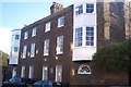
22 Dartmouth Hill
Has a blue plaque on the wall. See Image for close-up and more details.
Image: © David Anstiss
Taken: 27 Nov 2009
0.05 miles
10
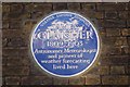
James Claisher Blue Plaque
On 22 Dartmouth Hill.
See http://en.wikipedia.org/wiki/James_Glaisher for more details about the man.
Image: © David Anstiss
Taken: 27 Nov 2009
0.05 miles