IMAGES TAKEN NEAR TO
Bessemer Place, LONDON, SE10 0ND
Introduction
This page details the photographs taken nearby to Bessemer Place, SE10 0ND by members of the Geograph project.
The Geograph project started in 2005 with the aim of publishing, organising and preserving representative images for every square kilometre of Great Britain, Ireland and the Isle of Man.

There are currently over 7.5m images from over14,400 individuals and you can help contribute to the project by visiting https://www.geograph.org.uk
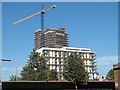
Image Map
Images are licensed for reuse under creativecommons.org/licenses/by-sa/2.0
Notes
- Clicking on the map will re-center to the selected point.
- The higher the marker number, the further away the image location is from the centre of the postcode.
Image Listing (191 Images Found)
Images are licensed for reuse under creativecommons.org/licenses/by-sa/2.0
Image
Details
Distance
1
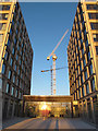
Entrance to two new blocks
A glass entrance lobby linking a pair of housing blocks forming the latest addition to the "Greenwich Millennium Village", opened in 2013. See Image The cranes behind show that there is another development being worked on closer to the river.
Image: © Stephen Craven
Taken: 11 Jan 2014
0.02 miles
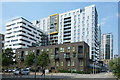
2

New housing in Greenwich Millennium Village
One of a pair of housing blocks forming the latest addition to the "Village", opened in 2013.
Image: © Stephen Craven
Taken: 11 Jan 2014
0.03 miles
4
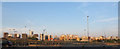
Greenwich Peninsula housing
A panoramic view across the peninsula showing the original Millennium Village at the right and more riverside apartment blocks being built to the left.
Image: © Stephen Craven
Taken: 8 Sep 2014
0.03 miles
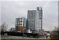
6
City Peninsula under construction (1)
A mainly residential development by Bellway on the east side of the Greenwich Peninsula, adjacent to the earlier Millennium Village.
Image: © Stephen Craven
Taken: 21 May 2011
0.03 miles
7
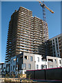
City Peninsula under construction (2)
A mainly residential development by Bellway on the east side of the Greenwich Peninsula, adjacent to the earlier Millennium Village. This view is from the riverside path.
Image: © Stephen Craven
Taken: 21 May 2011
0.03 miles
8
New Apartments, John Harrison Way
The most likely John Harrison to have a street named in this former maritime district is this one. Wikipedia says :- "John Harrison (3 April [O.S. 24 March] 1693 – 24 March 1776) was a self-educated English carpenter and clockmaker who invented a marine chronometer, a long-sought-after device for solving the problem of calculating longitude while at sea."
There are undoubtedly other John Harrisons, so this is only a guess.
Image: © Des Blenkinsopp
Taken: 22 May 2018
0.05 miles

10
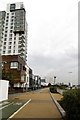
The Thames Path to Greenwich
The Thames Path is a National Trail, opened in 1996, following the length of the River Thames from its source near Kemble in Gloucestershire to the Thames Barrier at Charlton. It is about 184 miles long.
Image: © Steve Daniels
Taken: 6 Sep 2013
0.05 miles