IMAGES TAKEN NEAR TO
Armitage Road, LONDON, SE10 0HH
Introduction
This page details the photographs taken nearby to Armitage Road, SE10 0HH by members of the Geograph project.
The Geograph project started in 2005 with the aim of publishing, organising and preserving representative images for every square kilometre of Great Britain, Ireland and the Isle of Man.

There are currently over 7.5m images from over14,400 individuals and you can help contribute to the project by visiting https://www.geograph.org.uk
Image Map
Images are licensed for reuse under creativecommons.org/licenses/by-sa/2.0
Notes
- Clicking on the map will re-center to the selected point.
- The higher the marker number, the further away the image location is from the centre of the postcode.
Image Listing (157 Images Found)
Images are licensed for reuse under creativecommons.org/licenses/by-sa/2.0
Image
Details
Distance

2
Old road sign, Tunnel Avenue, East Greenwich
As this sign shows, the road gets its name from being the original route to the Blackwall Tunnel before the present A102 dual carriageway was built. HGVs are unlikely to come this way nowadays.
Image: © Stephen Craven
Taken: 22 Apr 2018
0.07 miles
3
Meantime brewery shop
The brewery has operated from this site on Blackwall Lane for a few years, but had only recently opened this on-site bar and shop. At the time of submission it had just been announced that Meantime Brewery, founded in 1999, had been bought by multinational drinks company SAB Miller.Source: http://www.theguardian.com/business/2015/may/15/sab-miller-buys-meantime-to-enter-uk-craft-beer-market
Image: © Stephen Craven
Taken: 16 May 2015
0.08 miles
4
Universal Tyres, Blackwall Lane, Greenwich
A contemporary design of workshop. The curved rear of the building can be seen in Image
Image: © Stephen Craven
Taken: 14 Feb 2009
0.08 miles
5
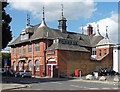
Rothbury Hall, Azof Street
Quite a turn-up in an otherwise architecturally under-endowed area (and missed by Pevsner), an attractive former Congregational mission. The roofline is a real treat. By W.T. Hollands, 1893-94. Grade II listed.
Now occupied by an arts company, Emergency Exit Arts.
Image: © Stephen Richards
Taken: 26 Sep 2015
0.09 miles
6
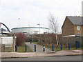
Footpath from Tunnel Avenue to the Odeon cinema
The footpath leads to the base of the steps to the footbridge over the A102, visible to the left of the photo. The cinema, visible in the background, was part of the Millennium development of the Greenwich peninsula, and the bridge may have been built at the same time.
Image: © Stephen Craven
Taken: 14 Feb 2009
0.09 miles
7
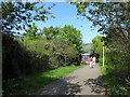
Footpath to the footbridge over the A102
This path has started to be come overgrown since my previous photo 9 years earlier Image
Image: © Stephen Craven
Taken: 22 Apr 2018
0.09 miles
8
Why stop here?
One of those off-road cycle lanes that just comes to a stop - with a give way sign and tactile paving - several yards short of a road junction, for no apparent reason. This is on Tunnel Avenue, North Greenwich.
Image: © Stephen Craven
Taken: 14 Feb 2009
0.09 miles
9
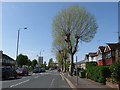
Tunnel Avenue, East Greenwich
The "Avenue" only has trees along one side now, though maybe there were along both sides originally. The road gets its name from being the original route to the Blackwall Tunnel before the present A102 dual carriageway was built.
Image: © Stephen Craven
Taken: 22 Apr 2018
0.09 miles
10
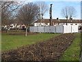
Geotechnical investigation, Tunnel Avenue
Exploratory boreholes were being sunk for a Thames Water project in 2009. The notices did not give an indication of the nature of the project, though it would more likely be for drainage or sewerage (which tends to be deeper) than water mains (which tend to be fairly shallow).
Later note (2011): I now realise this was almost certainly to do with the Thames Tideway sewer tunnel project.
Image: © Stephen Craven
Taken: 14 Feb 2009
0.10 miles