IMAGES TAKEN NEAR TO
East Parkside, LONDON, SE10 0FW
Introduction
This page details the photographs taken nearby to East Parkside, SE10 0FW by members of the Geograph project.
The Geograph project started in 2005 with the aim of publishing, organising and preserving representative images for every square kilometre of Great Britain, Ireland and the Isle of Man.

There are currently over 7.5m images from over14,400 individuals and you can help contribute to the project by visiting https://www.geograph.org.uk
Image Map
Images are licensed for reuse under creativecommons.org/licenses/by-sa/2.0
Notes
- Clicking on the map will re-center to the selected point.
- The higher the marker number, the further away the image location is from the centre of the postcode.
Image Listing (179 Images Found)
Images are licensed for reuse under creativecommons.org/licenses/by-sa/2.0
Image
Details
Distance
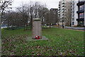
1

South Metropolitan Gas Co war memorial
Apart from the two remaining gasholders, this is the only reminder that nearly the whole of the Greenwich Peninsula was once given over to the production of town gas.
It is headed "To the glory of God and the grateful memory of those employees of the South Metropolitan Gas Company attached to the East Greenwich, Phoenix Wharf and Ordnance Wharf works who, in response to the call of their King and country, sacrificed their lives during the Great War". 81 names follow.
Image: © Stephen Craven
Taken: 16 May 2012
0.03 miles
2
Turf Zone "GrWarMemorial"
East Greenwich Gas Works War Memorial, Central Park, Greenwich.
Image: © Ian S
Taken: 25 Dec 2022
0.03 miles
3
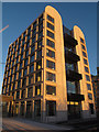
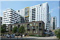
New housing in Greenwich Millennium Village
One of a pair of housing blocks forming the latest addition to the "Village", opened in 2013.
Image: © Stephen Craven
Taken: 11 Jan 2014
0.04 miles
4
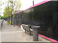
Seat with no view
I doubt that anyone has sat on this bench since the hoarding was erected in front of it. It would originally had a view across open land towards the river Thames but when the hoarding is removed it will be facing the new high-rise City Peninsula development Image
Image: © Stephen Craven
Taken: 16 May 2012
0.05 miles
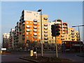
6
Entrance to two new blocks
A glass entrance lobby linking a pair of housing blocks forming the latest addition to the "Greenwich Millennium Village", opened in 2013. See Image The cranes behind show that there is another development being worked on closer to the river.
Image: © Stephen Craven
Taken: 11 Jan 2014
0.06 miles
7
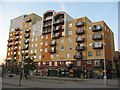
Metcalfe Court shops
A parade of shops occupies the ground floor of Metcalfe Court apartment block on West Parkside on the Greenwich Peninsula. At this time (2011) units included a Nisa convenience store, a pharmacy and dry-cleaner.
Image: © Stephen Craven
Taken: 19 Apr 2011
0.06 miles
9
New Apartments, John Harrison Way
The most likely John Harrison to have a street named in this former maritime district is this one. Wikipedia says :- "John Harrison (3 April [O.S. 24 March] 1693 – 24 March 1776) was a self-educated English carpenter and clockmaker who invented a marine chronometer, a long-sought-after device for solving the problem of calculating longitude while at sea."
There are undoubtedly other John Harrisons, so this is only a guess.
Image: © Des Blenkinsopp
Taken: 22 May 2018
0.07 miles
10
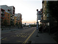
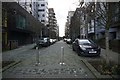
Bus stop on West Parkside
West Parkside, as part of a designed housing development on reclaimed industrial land on the Greenwich Peninsula, has a segregated bus lane. The lanes for other traffic can be seen behind. This stop is served by routes 108, 129, 132, 161, 472 and 486. Apart from 108 (Stratford-Lewisham) all these reoutes start at the North Greenwich transport interchange.
Image: © Stephen Craven
Taken: 19 Apr 2011
0.07 miles