IMAGES TAKEN NEAR TO
Maesyfron, SWANSEA, SA9 1XE
Introduction
This page details the photographs taken nearby to Maesyfron, SA9 1XE by members of the Geograph project.
The Geograph project started in 2005 with the aim of publishing, organising and preserving representative images for every square kilometre of Great Britain, Ireland and the Isle of Man.

There are currently over 7.5m images from over14,400 individuals and you can help contribute to the project by visiting https://www.geograph.org.uk
Image Map
Images are licensed for reuse under creativecommons.org/licenses/by-sa/2.0
Notes
- Clicking on the map will re-center to the selected point.
- The higher the marker number, the further away the image location is from the centre of the postcode.
Image Listing (44 Images Found)
Images are licensed for reuse under creativecommons.org/licenses/by-sa/2.0
Image
Details
Distance
1
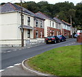
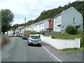
School Road houses, Abercrave
The houses are at the northern end of School Road, on the approach to Tanyrallt. http://www.geograph.org.uk/photo/3149523
Image: © Jaggery
Taken: 29 Aug 2011
0.02 miles
2
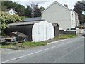
Boat-like corrugated metal building, Tanyrallt, Abercrave
The double-door corrugated metal building resembles an upturned boat. Viewed along Tanyrallt. http://www.geograph.org.uk/photo/3149523
Image: © Jaggery
Taken: 29 Aug 2011
0.03 miles
3
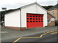
Abercrave Fire Station
Located at the southern end of Maesyfron, viewed across School Road.
The station is part of the Powys Command of the Mid and West Wales Fire and Rescue Service.
The grey training and drill tower http://www.geograph.org.uk/photo/3149499 is in the background.
Image: © Jaggery
Taken: 29 Aug 2011
0.04 miles
4
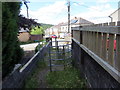
Llwybr cyhoeddus yn Abercraf / Footpath in Abercraf
Llwybr cyhoeddus yn cyrraedd pentre Abercraf. Mae'r llwybr yn dilyn hen ddramffordd a gludai calch i lawr o'r cware ar Gribarth.
A public footpath in the village of Abercraf (trans. confluence of the garlic stream). The path follows the former tramway that transported limestone down from the quarries on Cribarth (hillcrest).
Image: © Alan Richards
Taken: 20 Jul 2020
0.04 miles
5
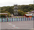
Fire tower and a colourful fence, Abercrave
The training and drill tower in behind the local fire station, http://www.geograph.org.uk/photo/3149509 out of shot on the right.
Viewed from School Road looking across the Abercrave Primary School site.
Image: © Jaggery
Taken: 29 Aug 2011
0.05 miles
6
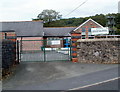
School gates, Abercrave
This is the School Road entrance to Abercrave Primary School.
The grey tower in the right background is part of the nearby fire station. http://www.geograph.org.uk/photo/3149509
Image: © Jaggery
Taken: 29 Aug 2011
0.05 miles
7
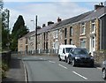
Tanyrallt houses, Abercrave
A view west along Tanyrallt, the street at the northern edge of the village.
Image: © Jaggery
Taken: 29 Aug 2011
0.08 miles
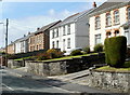
8
A row of houses, Heol Tawe, Abercrave
Numbers 15 to 29 Heol Tawe are set slightly above road level. Number 29 is nearest the camera. Number 15 is near the School Road junction.
Image: © Jaggery
Taken: 29 Aug 2011
0.09 miles
9
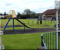
Children's play area, Abercrave
A view looking towards the Miners' Welfare Hall. http://www.geograph.org.uk/photo/3151206
Image: © Jaggery
Taken: 29 Aug 2011
0.10 miles
10
Heol Tawe houses west of the former Bryn Seion chapel, Abercrave
The houses are on the north side of the road, viewed from opposite a former chapel. http://www.geograph.org.uk/photo/3149423
Image: © Jaggery
Taken: 29 Aug 2011
0.10 miles