IMAGES TAKEN NEAR TO
Caerlan, Abercrave, SWANSEA, SA9 1SZ
Introduction
This page details the photographs taken nearby to SA9 1SZ by members of the Geograph project.
The Geograph project started in 2005 with the aim of publishing, organising and preserving representative images for every square kilometre of Great Britain, Ireland and the Isle of Man.

There are currently over 7.5m images from over14,400 individuals and you can help contribute to the project by visiting https://www.geograph.org.uk
Image Map
Images are licensed for reuse under creativecommons.org/licenses/by-sa/2.0
Notes
- Clicking on the map will re-center to the selected point.
- The higher the marker number, the further away the image location is from the centre of the postcode.
Image Listing (8 Images Found)
Images are licensed for reuse under creativecommons.org/licenses/by-sa/2.0
Image
Details
Distance
1
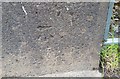
Ordnance Survey Cut Mark
This OS cut mark can be found on the NW parapet of the River Tawe Bridge. It marks a point 105.525m above mean sea level.
Image: © Adrian Dust
Taken: 27 May 2018
0.09 miles

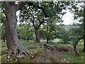
3
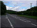
Road to the Sleeping Giant
A view along the section of the A4067 which bypasses Cae'r-Lan. This affords the best view of the Sleeping Giant - the profile of Cribarth as seen from the south-west.
Image: © Alan Bowring
Taken: 12 Jul 2008
0.13 miles
4
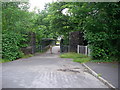
The old bridge over the Afon Tawe
The bridge carrying the old road over the waters of the Tawe was abandoned to walkers and pushbikes when the A4067 was realigned.
Image: © Alan Bowring
Taken: 12 Jul 2008
0.18 miles
5
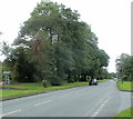
Tree-lined Brecon Road near Cae'r-Lan
A view along the A4067 from the edge of a right turn for the hamlet of Cae'r-Lan.
Image: © Jaggery
Taken: 29 Aug 2011
0.21 miles
7
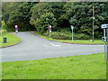
Road to Cae'r-Lan
Viewed across Brecon Road (the A4067). Cae'r-Lan is a hamlet to the west of Abercrave.
Image: © Jaggery
Taken: 29 Aug 2011
0.24 miles
8
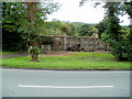
Derelict farm building near Cae'r-Lan
Viewed across Brecon Road (the A4067). The derelict building is on the west bank of the River Tawe.
Image: © Jaggery
Taken: 29 Aug 2011
0.24 miles